1930s Maps of Wall Street, Missouri
Explore 1 historic maps of Wall Street from the 1930s. These maps offer a rare glimpse into what life looked like during the 1930s — showing old roads, neighborhoods, homes, and landmarks that have changed or disappeared over time.
Whether you're researching your family's past, planning a metal detecting trip, or studying how Wall Street's landscape evolved across the 1930s, these high-resolution maps are a powerful tool for exploring the history of this region.
- Focus on a specific era: All maps on this page are from the 1930s, giving you a focused view of this time period.
- See what’s changed: Compare century-old streets, trails, and buildings to today's modern landscape using overlays and satellite layers.
- Research with precision: Use these maps for genealogy, historical research, land use analysis, or educational projects.
- View, download, or print: Maps are fully viewable online in high resolution, and can be downloaded or printed for your own records.
Start exploring Wall Street's history through authentic maps from the 1930s. This is your window into the past.
Wall Street, MO maps
(1)- 1939 Map of Long Lane, 1966 Print
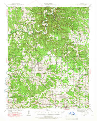 1939 Long Lane1966 Print · USGSDallas and Laclede Counties were defined by the winding Niangua River and the rural rail economy in the late 1930s. Genealogists can find numerous family-named landmarks like Williams Cem and isolated schools such as Blackfoot Sch.
End of results
Showing maps 1-1 of 1
Top cities near Wall Street
- Buffalo historical maps
- Fair Grove historical maps
- Conway historical maps
- Urbana historical maps
- Niangua historical maps
- Phillipsburg historical maps
See more
Frequently asked questions
- What are the different types of historical maps available for Wall Street?
- What is the oldest map of Wall Street?
- Where can I purchase historical maps of Wall Street for my home or office?
- Where can I download high-res historical maps of Wall Street?
- Are there historical topographic maps available for Wall Street?
- Is there historical aerial imagery available for Wall Street?
- Where are historical maps of Wall Street sourced from?