1930s Maps of Port Hudson, Missouri
Explore 1 historic maps of Port Hudson from the 1930s. These maps offer a rare glimpse into what life looked like during the 1930s — showing old roads, neighborhoods, homes, and landmarks that have changed or disappeared over time.
Whether you're researching your family's past, planning a metal detecting trip, or studying how Port Hudson's landscape evolved across the 1930s, these high-resolution maps are a powerful tool for exploring the history of this region.
- Focus on a specific era: All maps on this page are from the 1930s, giving you a focused view of this time period.
- See what’s changed: Compare century-old streets, trails, and buildings to today's modern landscape using overlays and satellite layers.
- Research with precision: Use these maps for genealogy, historical research, land use analysis, or educational projects.
- View, download, or print: Maps are fully viewable online in high resolution, and can be downloaded or printed for your own records.
Start exploring Port Hudson's history through authentic maps from the 1930s. This is your window into the past.
Port Hudson, MO maps
(1)- 1935 Map of Gerald
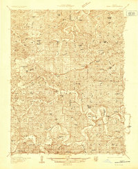 1935 Gerald1935 Print · USGSThe borderlands of Gasconade and Franklin counties are seen here in the mid-1930s as the Chicago Rock Island and Pacific railroad connects growing towns like Gerald and Rosebud. Local historians can trace dozens of rural school sites, including Buffalo Ridge School and Hinton Sch, alongside family-named landmarks and the meandering Bourbeuse River.
End of results
Showing maps 1-1 of 1
Top cities near Port Hudson
- Washington historical maps
- Union historical maps
- Sullivan historical maps
- Owensville historical maps
- New Haven historical maps
- Marthasville historical maps
See more
Frequently asked questions
- What are the different types of historical maps available for Port Hudson?
- What is the oldest map of Port Hudson?
- Where can I purchase historical maps of Port Hudson for my home or office?
- Where can I download high-res historical maps of Port Hudson?
- Are there historical topographic maps available for Port Hudson?
- Is there historical aerial imagery available for Port Hudson?
- Where are historical maps of Port Hudson sourced from?