1960s Maps of St. Clair, Missouri
Explore 6 historic maps of St. Clair from the 1960s. These maps offer a rare glimpse into what life looked like during the 1960s — showing old roads, neighborhoods, homes, and landmarks that have changed or disappeared over time.
Whether you're researching your family's past, planning a metal detecting trip, or studying how St. Clair's landscape evolved across the 1960s, these high-resolution maps are a powerful tool for exploring the history of this region.
- Focus on a specific era: All maps on this page are from the 1960s, giving you a focused view of this time period.
- See what’s changed: Compare century-old streets, trails, and buildings to today's modern landscape using overlays and satellite layers.
- Research with precision: Use these maps for genealogy, historical research, land use analysis, or educational projects.
- View, download, or print: Maps are fully viewable online in high resolution, and can be downloaded or printed for your own records.
Start exploring St. Clair's history through authentic maps from the 1960s. This is your window into the past.
St. Clair, MO maps
(6)- 1962 Map of St. Louis
 1962 St. Louis1962 Print · USGSThe mid-century gateway to the west shows the metropolitan expansion of St Louis alongside its critical river confluences. Genealogists and historians can trace the rail corridors of the Missouri Pacific RR and settlements from Fulton to De Soto.
 - 1963 Map of St. Louis, 1970 Print
 1963 St. Louis1970 Print · USGSSt. Louis and its surrounding river valleys are captured here during the peak of mid-century suburban expansion and industrial activity. Trace the historic rail routes of the Norfolk and Western Ry or locate the St Louis Ordnance Plant and early stretches of US Highway 66.4 unique versions available
 - 1965 Map of Stanton, 1967 Print
 1965 Stanton1967 Print · USGSFranklin County's river-carved landscape is shown here in the mid-1960s, just as modern highways began to parallel the historic St Louis-San Francisco rail line. Researchers can trace local genealogy through sites like Gum Rock Hill Ch and explore the rugged environs of Meramec State Park.3 unique versions available
 - 1966 Map of St. Louis
 1966 St. Louis1966 Print · USGSThe St. Louis metropolitan area and its surrounding river valleys are captured here during the mid-sixties era of suburban growth and industrial strength. Genealogists and historians can trace the foundations of local communities through sites like Old Pioneer Cem, Parks College, and the Jefferson Barracks Military Reservation.
 - 1969 Map of St. Clair, 1971 Print
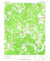
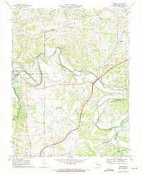
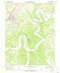 1969 St. Clair1971 Print · USGSFranklin County at the end of the sixties shows a landscape of growing towns and deep river valleys. Researchers can trace the rural church and cemetery network from Virginia Mines Ch to Cove Cem, or find river crossings like Plum Ford.2 unique versions available
 - 1969 Map of Moselle, 1971 Print
 1969 Moselle1971 Print · USGSFranklin County in the late sixties shows a transition between developing towns and the river valleys of the Bourbeuse and Meramec. Genealogists and historians can trace family locations near Gildehouse, Cheatham Cem, and the tracks of the St Louis-San Francisco railroad.3 unique versions available
End of results
Showing maps 1-6 of 6
Top cities near St. Clair
- Washington historical maps
- Union historical maps
- Pacific historical maps
- Sullivan historical maps
- Saint Clair historical maps
- Gray Summit historical maps
See more
Top neighborhoods of St. Clair
Frequently asked questions
- What are the different types of historical maps available for St. Clair?
- What is the oldest map of St. Clair?
- Where can I purchase historical maps of St. Clair for my home or office?
- Where can I download high-res historical maps of St. Clair?
- Are there historical topographic maps available for St. Clair?
- Is there historical aerial imagery available for St. Clair?
- Where are historical maps of St. Clair sourced from?