1980s Maps of West Plains, Missouri
Explore 5 historic maps of West Plains from the 1980s. These maps offer a rare glimpse into what life looked like during the 1980s — showing old roads, neighborhoods, homes, and landmarks that have changed or disappeared over time.
Whether you're researching your family's past, planning a metal detecting trip, or studying how West Plains's landscape evolved across the 1980s, these high-resolution maps are a powerful tool for exploring the history of this region.
- Focus on a specific era: All maps on this page are from the 1980s, giving you a focused view of this time period.
- See what’s changed: Compare century-old streets, trails, and buildings to today's modern landscape using overlays and satellite layers.
- Research with precision: Use these maps for genealogy, historical research, land use analysis, or educational projects.
- View, download, or print: Maps are fully viewable online in high resolution, and can be downloaded or printed for your own records.
Start exploring West Plains's history through authentic maps from the 1980s. This is your window into the past.
West Plains, MO maps
(5)- 1983 Map of West Plains, 1984 Print
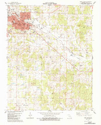 1983 West Plains1984 Print · USGSMissouri's Ozark plateau comes into view during the early 1980s, centered on the growing county seat of West Plains. Family historians can trace local landmarks like Parker Cem and Chapin Cem (Radio Cem) or locate rural school sites like Howell Valley Sch.
 - 1983 Map of South Fork, 1984 Print
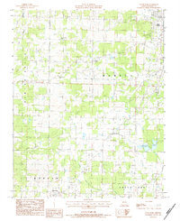 1983 South Fork1984 Print · USGSThe rural communities south of West Plains are documented here during the early eighties, showing a landscape defined by traditional Ozark farmsteads and creek valleys. Genealogists can locate family landmarks like Fairview Sch, Spring Creek Ch, and the small settlement of Homeland.
 - 1984 Map of West Plains
 1984 West Plains1984 Print · USGSThe Missouri Ozarks are mapped here in the mid-1980s, centered on the regional hub of West Plains and the river corridors of the Eleven Point River. Trace the old rail lines and timber towns of Willow Springs, Mountain View, and Birch Tree through the Mark Twain National Forest.2 unique versions available
 - 1986 Map of Pomona
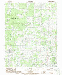 1986 Pomona1986 Print · USGSHowell County's rolling Ozark landscape appears in transition during the mid-eighties as the borders of West Plains expand northward toward Pomona. Researchers can trace rural lineages through sites like Mt Zion Ch and New Liberty Ch or locate the local Drag Strip.
 - 1986 Map of White Church
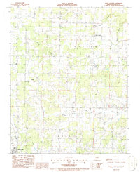 1986 White Church1986 Print · USGSHowell County in the mid-eighties shows a landscape of quiet rural settlements and winding valley creek systems. Researchers can trace the layout of West Plains near the Fairground or locate the namesake White Church and nearby Cem.
End of results
Showing maps 1-5 of 5
Top cities near West Plains
Top neighborhoods of West Plains
Frequently asked questions
- What are the different types of historical maps available for West Plains?
- What is the oldest map of West Plains?
- Where can I purchase historical maps of West Plains for my home or office?
- Where can I download high-res historical maps of West Plains?
- Are there historical topographic maps available for West Plains?
- Is there historical aerial imagery available for West Plains?
- Where are historical maps of West Plains sourced from?