1970s Maps of West Plains, Missouri
Explore 3 historic maps of West Plains from the 1970s. These maps offer a rare glimpse into what life looked like during the 1970s — showing old roads, neighborhoods, homes, and landmarks that have changed or disappeared over time.
Whether you're researching your family's past, planning a metal detecting trip, or studying how West Plains's landscape evolved across the 1970s, these high-resolution maps are a powerful tool for exploring the history of this region.
- Focus on a specific era: All maps on this page are from the 1970s, giving you a focused view of this time period.
- See what’s changed: Compare century-old streets, trails, and buildings to today's modern landscape using overlays and satellite layers.
- Research with precision: Use these maps for genealogy, historical research, land use analysis, or educational projects.
- View, download, or print: Maps are fully viewable online in high resolution, and can be downloaded or printed for your own records.
Start exploring West Plains's history through authentic maps from the 1970s. This is your window into the past.
West Plains, MO maps
(3)- 1976 Map of West Plains NW, 1977 Print
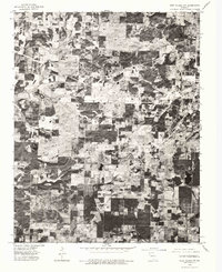 1976 West Plains NW1977 Print · USGSHowell County agriculture and timber tracts are seen in detail in the mid-1970s through this aerial survey. Local researchers can trace the rural landscape surrounding West Plains and the settlement of South Fork along the Spring River.
 - 1976 Map of West Plains, 1977 Print
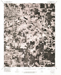 1976 West Plains1977 Print · USGSMid-seventies aerial photography captures the heart of the Ozarks as the community of West Plains expanded. Researchers can trace the layout of residential streets, agricultural field patterns, and the highway corridors that defined the town during this era.
 - 1976 Map of Willow Springs SW, 1977 Print
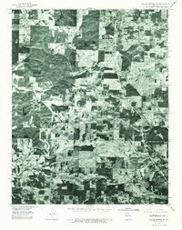 1976 Willow Springs SW1977 Print · USGSHowell County, Missouri, is shown here in the mid-seventies through detailed aerial imagery of the Ozark highlands. Local historians can examine the layout of rural communities and transportation corridors at Pomona and Olden.
End of results
Showing maps 1-3 of 3
Top cities near West Plains
Top neighborhoods of West Plains
Frequently asked questions
- What are the different types of historical maps available for West Plains?
- What is the oldest map of West Plains?
- Where can I purchase historical maps of West Plains for my home or office?
- Where can I download high-res historical maps of West Plains?
- Are there historical topographic maps available for West Plains?
- Is there historical aerial imagery available for West Plains?
- Where are historical maps of West Plains sourced from?