1940s Maps of Summers Addition, West Plains
Explore 3 historic maps of Summers Addition from the 1940s. These maps offer a rare glimpse into what life looked like during the 1940s — showing old roads, neighborhoods, homes, and landmarks that have changed or disappeared over time.
Whether you're researching your family's past, planning a metal detecting trip, or studying how Summers Addition's landscape evolved across the 1940s, these high-resolution maps are a powerful tool for exploring the history of this region.
- Focus on a specific era: All maps on this page are from the 1940s, giving you a focused view of this time period.
- See what’s changed: Compare century-old streets, trails, and buildings to today's modern landscape using overlays and satellite layers.
- Research with precision: Use these maps for genealogy, historical research, land use analysis, or educational projects.
- View, download, or print: Maps are fully viewable online in high resolution, and can be downloaded or printed for your own records.
Start exploring Summers Addition's history through authentic maps from the 1940s. This is your window into the past.
Summers Addition, West Plains maps
(3)- 1940 Map of West Plains
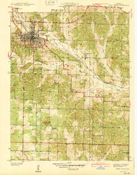 1940 West Plains1940 Print · USGSWest Plains was a bustling Ozark rail hub just before the mid-century, surrounded by a landscape of family farms and valley schools. Genealogists can locate specific local landmarks like County Home, Smith Chapel, and the St Louis San Francisco rail corridor.
 - 1944 Map of West Plains, 1957 Print
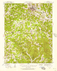 1944 West Plains1957 Print · USGSThe West Plains region at the close of the Second World War remains a landscape of rail-connected commerce and scattered rural school districts. Genealogists can locate family names at Saddle Cem, Neubarger Sch, or the rural community of Lanton.2 unique versions available
 - 1946 Map of West Plains
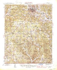 1946 West Plains1946 Print · USGSHowell County's rolling uplands and rural communities are captured here in the mid-1940s, centered on the growing hub of West Plains. Researchers can trace dozens of vanished country school sites and family-linked landmarks like Pleasant Hill Ch, Mc Elmery Cem, and Moody.2 unique versions available
End of results
Showing maps 1-3 of 3
Top cities near Summers Addition
Frequently asked questions
- What are the different types of historical maps available for Summers Addition?
- What is the oldest map of Summers Addition?
- Where can I purchase historical maps of Summers Addition for my home or office?
- Where can I download high-res historical maps of Summers Addition?
- Are there historical topographic maps available for Summers Addition?
- Is there historical aerial imagery available for Summers Addition?
- Where are historical maps of Summers Addition sourced from?