1990s Maps of Blue Springs, Missouri
Explore 5 historic maps of Blue Springs from the 1990s. These maps offer a rare glimpse into what life looked like during the 1990s — showing old roads, neighborhoods, homes, and landmarks that have changed or disappeared over time.
Whether you're researching your family's past, planning a metal detecting trip, or studying how Blue Springs's landscape evolved across the 1990s, these high-resolution maps are a powerful tool for exploring the history of this region.
- Focus on a specific era: All maps on this page are from the 1990s, giving you a focused view of this time period.
- See what’s changed: Compare century-old streets, trails, and buildings to today's modern landscape using overlays and satellite layers.
- Research with precision: Use these maps for genealogy, historical research, land use analysis, or educational projects.
- View, download, or print: Maps are fully viewable online in high resolution, and can be downloaded or printed for your own records.
Start exploring Blue Springs's history through authentic maps from the 1990s. This is your window into the past.
Blue Springs, MO maps
(5)- 1990 Map of Oak Grove, 1995 Print
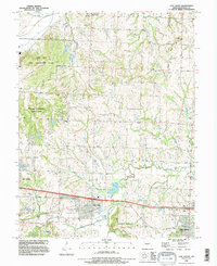 1990 Oak Grove1995 Print · USGSJackson County in the early nineties shows a landscape of suburban expansion meeting deep-rooted rural history. Genealogists and researchers can trace local lineage through the Levasy Cem and Oakland Cem or locate the sprawling Lake City Army Ammunition Plant.
 - 1990 Map of Blue Springs, 1995 Print
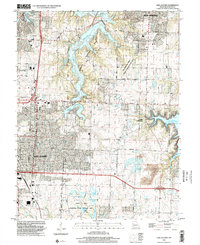
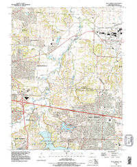 1990 Blue Springs1995 Print · USGSJackson County's eastern expansion is captured in the early nineties, showcasing the balance between massive federal facilities and suburban growth. Genealogists and historians can trace local landmarks like Lobb Cemetery, the Lake City Army Ammunition Plant, and Selsa.
 - 1990 Map of Lake Jacomo, 1995 Print
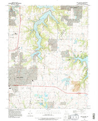 1990 Lake Jacomo1995 Print · USGSJackson County enters a period of significant suburban growth in the 1990s as recreation and aviation hubs expand. Trace the development of Lees Summit and Blue Springs alongside major water projects like Lake Jacomo and Lake Lotawana.
 - 1990 Map of Tarsney Lakes, 1996 Print
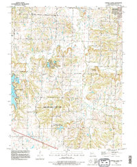 1990 Tarsney Lakes1996 Print · USGSEastern Jackson County is shown here in the 1990s, where the winding Sni-A-Bar Creek meets small settlements and sprawling county parks. Genealogists can locate family-named landmarks like Purdee Chapel Cem or trace the early footprint of Tarsney Lakes.
 - 1996 Map of Lake Jacomo, 2002 Print
 1996 Lake Jacomo2002 Print · USGSEastern Jackson County is shown during a period of rapid suburban growth in the late nineties. Researchers can trace development near Lees Summit and Blue Springs, or explore the many lakes within the James A Reed Memorial State Wildlife Area.
End of results
Showing maps 1-5 of 5
Top cities near Blue Springs
- Kansas City historical maps
- Independence historical maps
- Lee's Summit historical maps
- Liberty historical maps
- Raytown historical maps
- Grandview historical maps
See more
Frequently asked questions
- What are the different types of historical maps available for Blue Springs?
- What is the oldest map of Blue Springs?
- Where can I purchase historical maps of Blue Springs for my home or office?
- Where can I download high-res historical maps of Blue Springs?
- Are there historical topographic maps available for Blue Springs?
- Is there historical aerial imagery available for Blue Springs?
- Where are historical maps of Blue Springs sourced from?