1960s Maps of Jasper County, Missouri
Explore 10 historic maps of Jasper County from the 1960s. These maps offer a rare glimpse into what life looked like during the 1960s — showing old roads, neighborhoods, homes, and landmarks that have changed or disappeared over time.
Whether you're researching your family's past, planning a metal detecting trip, or studying how Jasper County's landscape evolved across the 1960s, these high-resolution maps are a powerful tool for exploring the history of this region.
- Focus on a specific era: All maps on this page are from the 1960s, giving you a focused view of this time period.
- See what’s changed: Compare century-old streets, trails, and buildings to today's modern landscape using overlays and satellite layers.
- Research with precision: Use these maps for genealogy, historical research, land use analysis, or educational projects.
- View, download, or print: Maps are fully viewable online in high resolution, and can be downloaded or printed for your own records.
Start exploring Jasper County's history through authentic maps from the 1960s. This is your window into the past.
Jasper County, MO maps
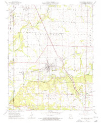
(10)- 1962 Map of Jasper, 1963 Print
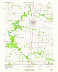 1962 Jasper1963 Print · USGSJasper and its surrounding townships are shown in the early 1960s as the rail-and-road network supported a thriving rural community. Genealogists can trace family roots through numerous local landmarks, including Stafford Cem, Salem Ch, and the settlement of Carytown.2 unique versions available
 - 1962 Map of Neck City, 1963 Print
 1962 Neck City1963 Print · USGSThe mining landscapes of Jasper County are clearly visible in the early sixties, centered around the industrial activity of Neck City. Researchers can trace the remnants of the Old Railroad Grade and locate family history at Gresham Cem and Preston.2 unique versions available
 - 1962 Map of Dudenville, 1963 Print
 1962 Dudenville1963 Print · USGSSouthwest Missouri farmland and rural townships are captured here in the early 1960s at the junction of four counties. Genealogists and local historians can trace the foundations of Dudenville, the location of Unity Sch, and the grounds of Kistler Cem.2 unique versions available
 - 1962 Map of Maple Grove, 1964 Print
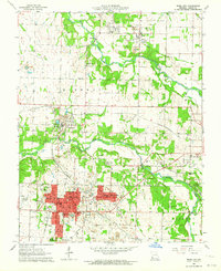
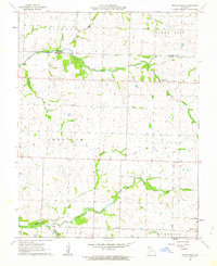 1962 Maple Grove1964 Print · USGSJasper County during the early 1960s was a patchwork of family farms and rural townships spanning the Barton County line. Genealogists and historians can locate legacy landmarks like Maple Grove, the Spring Hill Sch, and Mitchell Cem.
 - 1962 Map of Joplin West, 1964 Print
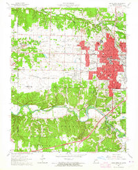 1962 Joplin West1964 Print · USGSJoplin and the Missouri-Kansas borderlands are shown here in the early sixties, still bearing the visible scars and structures of the region's mining boom. Genealogists and historians can trace local families through many sites including Fairview Cemetery, Peace Church, and the neighborhood of Chitwood.2 unique versions available
 - 1963 Map of Carthage, 1964 Print
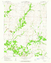
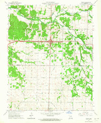
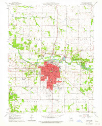 1963 Carthage1964 Print · USGSCarthage and its surrounding Jasper County townships are captured here in the early sixties as a bustling hub of rail, industry, and education. Researchers can trace family roots at Park Cemetery or locate old school sites like Lone Star Sch and Our Lady of the Ozarks College.2 unique versions available
 - 1963 Map of Webb City, 1964 Print
 1963 Webb City1964 Print · USGSIn the early 1960s, this pocket of Jasper County shows the overlap of Missouri's mining heritage and mid-century growth. Researchers can trace historical lead-and-zinc sites like Oronogo alongside landmarks like Mark Twain School and Mt Hope Cemetery.2 unique versions available
 - 1963 Map of Joplin East, 1964 Print
 1963 Joplin East1964 Print · USGSJasper County in the early sixties shows the industrial transition of a major mining district. Trace the legacy of the lead belt through Tailings piles near Duenweg or find family landmarks like Underwood Sch and Harmony Grove Cem.3 unique versions available
 - 1963 Map of Carl Junction, 1964 Print
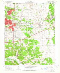
 1963 Carl Junction1964 Print · USGSThe Joplin periphery during the early 1960s reveals a landscape shaped by mining and rail, from the Spring River to the growing suburbs. Researchers can locate vanished infrastructure like the Old Railroad Grade and trace family roots at Twin Grove Cem or Brick Sch.2 unique versions available
 - 1963 Map of Fidelity, 1964 Print
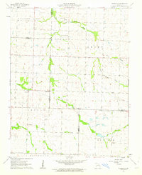
 1963 Fidelity1964 Print · USGSJasper and Newton counties are captured here in the early sixties, showing the rural communities between Fidelity and Diamond. Local historians can trace family roots through several legacy sites, including Stone Cem, Fullerton Cem, and the Liberty Ch.2 unique versions available
End of results
Showing maps 1-10 of 10
Top cities of Jasper County
- Carthage historical maps
- Webb City historical maps
- Carl Junction historical maps
- Oronogo historical maps
- Carterville historical maps
- Duquesne historical maps
See more
Frequently asked questions
- What are the different types of historical maps available for Jasper County?
- What is the oldest map of Jasper County?
- Where can I purchase historical maps of Jasper County for my home or office?
- Where can I download high-res historical maps of Jasper County?
- Are there historical topographic maps available for Jasper County?
- Is there historical aerial imagery available for Jasper County?
- Where are historical maps of Jasper County sourced from?