1960s Maps of Webb City, Missouri
Explore 2 historic maps of Webb City from the 1960s. These maps offer a rare glimpse into what life looked like during the 1960s — showing old roads, neighborhoods, homes, and landmarks that have changed or disappeared over time.
Whether you're researching your family's past, planning a metal detecting trip, or studying how Webb City's landscape evolved across the 1960s, these high-resolution maps are a powerful tool for exploring the history of this region.
- Focus on a specific era: All maps on this page are from the 1960s, giving you a focused view of this time period.
- See what’s changed: Compare century-old streets, trails, and buildings to today's modern landscape using overlays and satellite layers.
- Research with precision: Use these maps for genealogy, historical research, land use analysis, or educational projects.
- View, download, or print: Maps are fully viewable online in high resolution, and can be downloaded or printed for your own records.
Start exploring Webb City's history through authentic maps from the 1960s. This is your window into the past.
Webb City, MO maps
(2)- 1963 Map of Webb City, 1964 Print
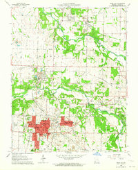 1963 Webb City1964 Print · USGSIn the early 1960s, this pocket of Jasper County shows the overlap of Missouri's mining heritage and mid-century growth. Researchers can trace historical lead-and-zinc sites like Oronogo alongside landmarks like Mark Twain School and Mt Hope Cemetery.2 unique versions available
 - 1963 Map of Joplin East, 1964 Print
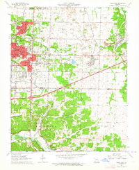 1963 Joplin East1964 Print · USGSJasper County in the early sixties shows the industrial transition of a major mining district. Trace the legacy of the lead belt through Tailings piles near Duenweg or find family landmarks like Underwood Sch and Harmony Grove Cem.3 unique versions available
End of results
Showing maps 1-2 of 2
Top cities near Webb City
- Joplin historical maps
- Carthage historical maps
- Carl Junction historical maps
- Galena historical maps
- Granby historical maps
- Oronogo historical maps
See more
Top neighborhoods of Webb City
Frequently asked questions
- What are the different types of historical maps available for Webb City?
- What is the oldest map of Webb City?
- Where can I purchase historical maps of Webb City for my home or office?
- Where can I download high-res historical maps of Webb City?
- Are there historical topographic maps available for Webb City?
- Is there historical aerial imagery available for Webb City?
- Where are historical maps of Webb City sourced from?