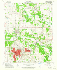
1963 Map of Webb City
USGS Topo · Published 1964About this map
Webb City and Carterville anchor this 1963 survey of Jasper County's industrial heart, where the legacies of lead and zinc mining dominate the landscape. Extensive areas marked by Tailings, Mines, and Mine Dump labels trace the extraction history that shaped these communities, particularly around Oronogo and Alba. The region's transition into a modern hub is visible through the expansion of the Joplin Airport and the presence of the Drive-in Theater near the city limits.
Find a feature on this map
47 named features on this map. Tap any name to fly to it.
Don’t see what you’re looking for? This feature index may not catch every label — zoom into the map to look around manually.
Map Details
Editions of this 1963 Webb City Map
2 editions found
Other maps of this area

1886 · Joplin
USGS Topo · 1:125,000

1886 · Carthage
USGS Topo · 1:125,000

1894 · Joplin
USGS Topo · 1:125,000

1894 · Carthage
USGS Topo · 1:125,000

1945 · Pittsburg
USGS Topo · 1:62,500

1947 · Joplin
USGS Topo · 1:250,000

1947 · Pittsburg
USGS Topo · 1:62,500

1949 · Joplin
USGS Topo · 1:250,000

1950 · Pittsburg
USGS Topo · 1:62,500

1954 · Joplin
USGS Topo · 1:250,000