Old Maps of Rock Township, Missouri for Genealogy
Trace your family roots with 39 historic maps of Rock Township. These high-res maps reveal old neighborhoods, homesites, landmarks, and streets — helping you uncover where your ancestors lived and how the area evolved over time.
- Explore historic neighborhoods: Identify where your relatives may have lived in the 1800s or 1900s.
- Compare maps over time: Trace the changes in streets, buildings, and landmarks for multi-generational research.
- Perfect for genealogy & ancestry research: Used by family historians and researchers to map out lineage and migration.
These maps are an incredible resource for exploring your personal connection to Rock Township's past.
Rock Township, MO maps
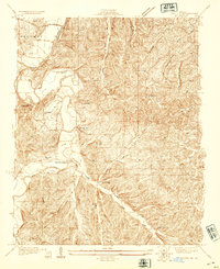
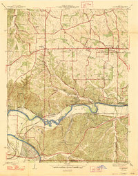
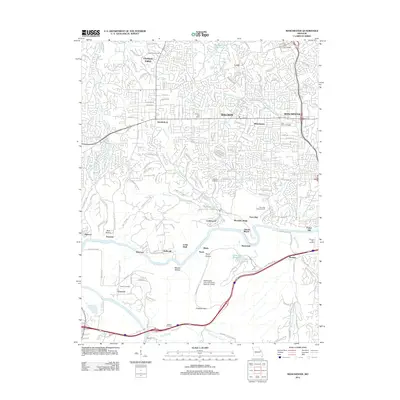
(39)- 1901 Map of De Soto
 1901 De Soto1901 Print · USGSJefferson and Franklin Counties at the turn of the century show a landscape defined by industrial milling and river fords. Genealogists can trace early homesteads near Hillsboro or industrial sites like Vulcan Mine and Byrnes Mill.5 unique versions available
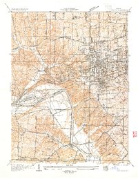
 - 1903 Map of O'Fallon
 1903 O'Fallon1903 Print · USGSSt. Charles County at the turn of the century is a labyrinth of river islands and rail lines at the confluence of the Missouri and Mississippi. Researchers can trace old river landings like Cap Au Gris Landing and family-named settlements from Moscow Mills to New Melle.5 unique versions available
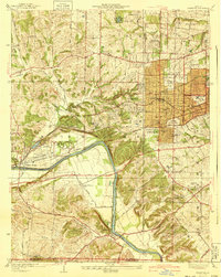
 - 1912 Map of Kimmswick
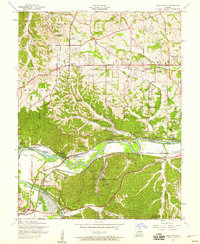
 1912 Kimmswick1912 Print · USGSThe Illinois bottomlands along the Mississippi River are shown here in the early twentieth century, just as the railroad was solidifying the region's economy. Genealogists and local researchers can trace the locations of Harrisonville, the Blue Church, and historic schools like Miles Prairie School.2 unique versions available
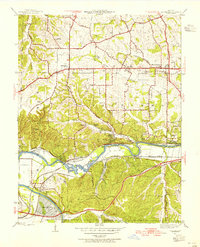
 - 1916 Map of Kimmswick
 1916 Kimmswick1916 Print · USGSThe Mississippi River valley comes alive in this early twentieth-century survey of the Missouri-Illinois borderlands. Genealogists and historians can trace defunct schoolhouses like Fawn Ridge School, river landings such as Harrisonville Landing, and the path of the St Louis Iron Mountain and Southern RR.6 unique versions available
 - 1931 Map of Manchester SE
 1931 Manchester SE1931 Print · USGSSt. Louis County and Jefferson County were still largely defined by the river and rail lines during the early 1930s. Researchers can trace the early layout of Times Beach or locate family-history landmarks like the Rankin Cem and Oak Ridge Sch.
 - 1931 Map of Pacific NE
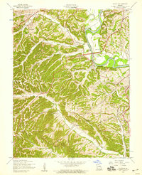
 1931 Pacific NE1931 Print · USGSJefferson County was a land of river bends and rural schools in the early thirties. Local historians can trace the foundations of communities at Byrnes Mill and House Springs, or locate old schoolhouse sites like Whiteoak Sch and Cedar Sch.2 unique versions available
 - 1933 Map of Kirkwood
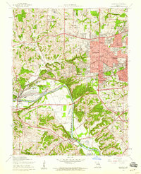
 1933 Kirkwood1933 Print · USGSSt. Louis County is captured here during a period of rapid suburban and institutional expansion in the early thirties. Genealogists and local researchers can trace the footprint of Oakhill Cemetery, Meacham Park, and the grounds of Hartman College.
 - 1940 Map of Kirkwood
 1940 Kirkwood1940 Print · USGSSt. Louis County shows its rapid suburban and institutional growth before the mid-century boom. Genealogists and historians can trace the rail-centered development of Kirkwood and find vanished landmarks like Windsor Springs and Hartman College.3 unique versions available
 - 1945 Map of Manchester, 1955 Print
 1945 Manchester1955 Print · USGSWestern St. Louis County is shown at a pivotal moment in the 1940s as suburban growth began to meet rural river life. Genealogists and historians can trace old homesteads and landmarks like Times Beach, Sherman P O, and the Sulphur Springs Sch.
 - 1947 Map of Manchester
 1947 Manchester1947 Print · USGSSt. Louis County is captured here just after the war, showing the distinct identities of communities along the historic Manchester Road. Genealogists and historians can locate family landmarks like the Ranken Cem, several local schoolhouses, and the original street grid of Times Beach.2 unique versions available
 - 1948 Map of Kimmswick, 1955 Print
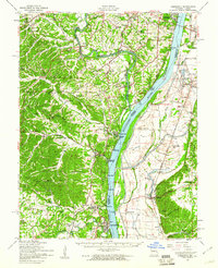
 1948 Kimmswick1955 Print · USGSThe Mississippi River corridor south of St. Louis appears here at a mid-century peak of rail and river industry. Researchers can trace historic river landings and rural schools like Harrisonville Landing, Blue Church, and the sprawling grounds of Jefferson Barracks.
 - 1949 Map of Saint Louis
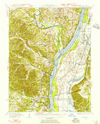
 1949 Saint Louis1949 Print · USGSGreater St. Louis and its surrounding river valleys are captured here just after the war, showing the metropolitan core and the rural Ozark fringe. Researchers can trace the sprawling rail network of the Wabash RR or locate landmarks like Meramec Caverns Airport and Scott Air Force Base.2 unique versions available
 - 1954 Map of House Springs, 1956 Print
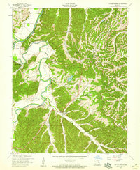 1954 House Springs1956 Print · USGSJefferson County in the mid-1950s is a landscape of winding river valleys and ridge-top settlements. Researchers can trace the development of High Ridge and House Springs or locate family landmarks like Byrnes Mill, Hoene Spring, and St Martins Ch.8 unique versions available
 - 1954 Map of Kirkwood, 1959 Print
 1954 Kirkwood1959 Print · USGSPost-war St. Louis County suburbs expand across the Meramec River valley in the mid-fifties as new neighborhoods surround historic rail lines. Genealogists can trace family roots at Marshall Cem or explore sites like Weiss Airport and Ursuline Academy.7 unique versions available
 - 1954 Map of Manchester, 1959 Print
 1954 Manchester1959 Print · USGSThe Meramec valley and western St. Louis County are seen here in the mid-fifties, during a period of suburban expansion and industrial utility. Genealogists can locate family landmarks like Lewis Cem, the Oak Ridge Sch (Abandoned), and the original platting of Times Beach.8 unique versions available
 - 1954 Map of Maxville, 1959 Print
 1954 Maxville1959 Print · USGSJefferson County and the St. Louis border are shown here during the mid-fifties, just as rural valley life met new transportation growth. Genealogists can locate family landmarks like McCormack Cem, Bowles Sch, and the winding Lemay Ferry Road.5 unique versions available
 - 1954 Map of Kimmswick, 1960 Print
 1954 Kimmswick1960 Print · USGSThe Mississippi River corridor south of St. Louis comes to life in the mid-fifties, showing the rail-dependent towns of Kimmswick and Herculaneum. Genealogists and historians can trace family landmarks like Richardson Cem, Point Sch, and Harrisonville Landing.2 unique versions available
 - 1962 Map of St. Louis
 1962 St. Louis1962 Print · USGSThe mid-century gateway to the west shows the metropolitan expansion of St Louis alongside its critical river confluences. Genealogists and historians can trace the rail corridors of the Missouri Pacific RR and settlements from Fulton to De Soto.
 - 1963 Map of St. Louis, 1970 Print
 1963 St. Louis1970 Print · USGSSt. Louis and its surrounding river valleys are captured here during the peak of mid-century suburban expansion and industrial activity. Trace the historic rail routes of the Norfolk and Western Ry or locate the St Louis Ordnance Plant and early stretches of US Highway 66.4 unique versions available
 - 1966 Map of St. Louis
 1966 St. Louis1966 Print · USGSThe St. Louis metropolitan area and its surrounding river valleys are captured here during the mid-sixties era of suburban growth and industrial strength. Genealogists and historians can trace the foundations of local communities through sites like Old Pioneer Cem, Parks College, and the Jefferson Barracks Military Reservation.
 - 1979 Map of Manchester, 1981 Print
 1979 Manchester1981 Print · USGSWestern St. Louis County suburban expansion is captured here in the late seventies as residential tracts fill the space between established towns. Trace the streets of Times Beach or the riverfront of Valley Park along the Meramec River.
 - 1985 Map of St Louis
 1985 St Louis1985 Print · USGSThe St. Louis metropolitan area and its river confluences are captured here during a period of significant suburban expansion in the 1980s. Genealogists and historians can trace the development of older neighborhoods and landmarks like Jefferson Barracks, Cahokia Mounds State Park, and Washington University.3 unique versions available
 - 1985 Map of Festus, 1987 Print
 1985 Festus1987 Print · USGSThe Mississippi River corridor and Ozark foothills appear here in the mid-1980s, documenting a landscape of industrial river towns and forest preserves. Trace the development of Festus, Crystal City, and De Soto or locate sites like Mastodon State Park.
 - 2012 Map of Kirkwood, 2012 Print
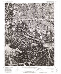
 2012 Kirkwood2012 Print · USGSCovers Rock Township, including Kirkwood, Webster Groves, and other nearby areas
 - 2012 Map of Manchester, 2012 Print
 2012 Manchester2012 Print · USGSCovers Rock Township, including Chesterfield, Wildwood, and other nearby areas
Showing maps 1-25 of 39
Top cities near Rock Township
- Chesterfield historical maps
- Oakville historical maps
- Wildwood historical maps
- University City historical maps
- Ballwin historical maps
- Kirkwood historical maps
See more
Top neighborhoods of Rock Township
- Shady Valley historical maps
- Rock Creek historical maps
- Jefferson Heights historical maps
- Murphy historical maps
Frequently asked questions
- What are the different types of historical maps available for Rock Township?
- What is the oldest map of Rock Township?
- Where can I purchase historical maps of Rock Township for my home or office?
- Where can I download high-res historical maps of Rock Township?
- Are there historical topographic maps available for Rock Township?
- Is there historical aerial imagery available for Rock Township?
- Where are historical maps of Rock Township sourced from?