1980s Maps of Knox County, Missouri
Explore 4 historic maps of Knox County from the 1980s. These maps offer a rare glimpse into what life looked like during the 1980s — showing old roads, neighborhoods, homes, and landmarks that have changed or disappeared over time.
Whether you're researching your family's past, planning a metal detecting trip, or studying how Knox County's landscape evolved across the 1980s, these high-resolution maps are a powerful tool for exploring the history of this region.
- Focus on a specific era: All maps on this page are from the 1980s, giving you a focused view of this time period.
- See what’s changed: Compare century-old streets, trails, and buildings to today's modern landscape using overlays and satellite layers.
- Research with precision: Use these maps for genealogy, historical research, land use analysis, or educational projects.
- View, download, or print: Maps are fully viewable online in high resolution, and can be downloaded or printed for your own records.
Start exploring Knox County's history through authentic maps from the 1980s. This is your window into the past.
Knox County, MO maps
(4)- 1981 Map of Macon
 1981 Macon1981 Print · USGSNorthern Missouri's rail-and-river landscape is captured here in the early eighties, centered on the crossroads of Macon. Researchers can trace old cemetery sites like St Marys Cem, local landmarks such as College Mound, and the routes of the Burlington Northern railroad.
 - 1981 Map of Kirksville, 1982 Print
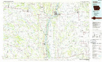
 1981 Kirksville1982 Print · USGSNortheast Missouri in the early eighties was a landscape of rail-connected trade towns and significant river valleys. Researchers can trace the legacy of medical education at the Kirksville College of Osteopathic Med or locate family roots in Unionville, Edina, and Bible Grove.
 - 1986 Map of Quincy
 1986 Quincy1986 Print · USGSThe tri-state border region along the Mississippi River comes into focus during the mid-1980s. Researchers can trace the legacy of river towns and rail hubs like Quincy and Monroe City or locate landmarks such as Mount Olive Cem.2 unique versions available
 - 1986 Map of Keokuk
 1986 Keokuk1986 Print · USGSThe tri-state junction of Iowa, Illinois, and Missouri comes alive in the mid-eighties as a hub of river commerce and rail transit. Researchers can trace family roots through Moss Ridge Cemetery or study industrial landmarks like the Keokuk Dam and Lock and Dam No 19.2 unique versions available
End of results
Showing maps 1-4 of 4
Top cities of Knox County
- Edina historical maps
- Hurdland historical maps
- Knox City historical maps
- Baring historical maps
- Novelty historical maps
- Newark historical maps
Frequently asked questions
- What are the different types of historical maps available for Knox County?
- What is the oldest map of Knox County?
- Where can I purchase historical maps of Knox County for my home or office?
- Where can I download high-res historical maps of Knox County?
- Are there historical topographic maps available for Knox County?
- Is there historical aerial imagery available for Knox County?
- Where are historical maps of Knox County sourced from?