1940s Maps of Carrol Junction, Missouri
Explore 2 historic maps of Carrol Junction from the 1940s. These maps offer a rare glimpse into what life looked like during the 1940s — showing old roads, neighborhoods, homes, and landmarks that have changed or disappeared over time.
Whether you're researching your family's past, planning a metal detecting trip, or studying how Carrol Junction's landscape evolved across the 1940s, these high-resolution maps are a powerful tool for exploring the history of this region.
- Focus on a specific era: All maps on this page are from the 1940s, giving you a focused view of this time period.
- See what’s changed: Compare century-old streets, trails, and buildings to today's modern landscape using overlays and satellite layers.
- Research with precision: Use these maps for genealogy, historical research, land use analysis, or educational projects.
- View, download, or print: Maps are fully viewable online in high resolution, and can be downloaded or printed for your own records.
Start exploring Carrol Junction's history through authentic maps from the 1940s. This is your window into the past.
Carrol Junction, MO maps
(2)- 1941 Map of Lebanon, 1968 Print
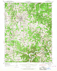 1941 Lebanon1968 Print · USGSLebanon and the surrounding Laclede County uplands are captured here in the early 1940s, just as the region was defined by Route 66 and a network of one-room schools. Genealogists can locate family landmarks like Atchley Cem and Santiago Cem, or trace vanished rural hubs such as Caffeyville and Orla.
 - 1943 Map of Lebanon
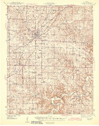 1943 Lebanon1943 Print · USGSLaclede County at the start of the 1940s reveals a landscape where the St Louis San Francisco railway and early aviation at Lebanon Airport met deep-rooted Ozark settlements. Genealogists can trace family footprints across dozens of local landmarks like Roper Cem, Hough Chapel, and the Bear Thicket Sch.2 unique versions available
End of results
Showing maps 1-2 of 2
Top cities near Carrol Junction
- Lebanon historical maps
- Richland historical maps
- Conway historical maps
- Phillipsburg historical maps
- Evergreen historical maps
- Caffeyville historical maps
Frequently asked questions
- What are the different types of historical maps available for Carrol Junction?
- What is the oldest map of Carrol Junction?
- Where can I purchase historical maps of Carrol Junction for my home or office?
- Where can I download high-res historical maps of Carrol Junction?
- Are there historical topographic maps available for Carrol Junction?
- Is there historical aerial imagery available for Carrol Junction?
- Where are historical maps of Carrol Junction sourced from?