1900s (20th Century) Maps of Conway, Missouri
Explore 11 historic maps of Conway from the 1900s (20th Century). These maps offer a rare glimpse into what life looked like during the 1900s — showing old roads, neighborhoods, homes, and landmarks that have changed or disappeared over time.
Whether you're researching your family's past, planning a metal detecting trip, or studying how Conway's landscape evolved across the 1900s, these high-resolution maps are a powerful tool for exploring the history of this region.
- Focus on a specific era: All maps on this page are from the 1900s, giving you a focused view of this time period.
- See what’s changed: Compare century-old streets, trails, and buildings to today's modern landscape using overlays and satellite layers.
- Research with precision: Use these maps for genealogy, historical research, land use analysis, or educational projects.
- View, download, or print: Maps are fully viewable online in high resolution, and can be downloaded or printed for your own records.
Start exploring Conway's history through authentic maps from the 1900s. This is your window into the past.
Conway, MO maps
(11)- 1939 Map of Long Lane, 1966 Print
 1939 Long Lane1966 Print · USGSDallas and Laclede Counties were defined by the winding Niangua River and the rural rail economy in the late 1930s. Genealogists can find numerous family-named landmarks like Williams Cem and isolated schools such as Blackfoot Sch.
 - 1942 Map of Long Lane
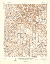 1942 Long Lane1942 Print · USGSThe Ozark plateau comes alive in the early 1940s, showing a land defined by the winding Niangua River and the rural townships of Wilson and Union. Researchers can trace dozens of country schoolhouses like Lonesome Hill Sch and Loudon Smoke Sch or locate ancestors near Shanks Cem.3 unique versions available
 - 1946 Map of Niangua, 1966 Print
 1946 Niangua1966 Print · USGSMid-century Webster County is shown here during a time when rural life centered on the St Louis-San Francisco rail line and local country schools. Genealogists can locate family landmarks such as Bumgardner Ford, Eighty Eight Sch, and Sparkle Brook Cem.
 - 1948 Map of Niangua
 1948 Niangua1948 Print · USGSIn the late 1940s, Webster County was a landscape of small farming communities and river crossings. Trace the old rail line to Marshfield or find rural landmarks like Eighty Eight Sch, Mission Home Ch, and the crossings at Johnston Ford.2 unique versions available
 - 1954 Map of Springfield
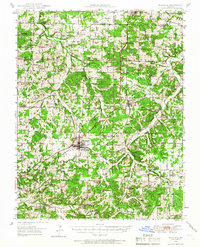
 1954 Springfield1954 Print · USGSThe Missouri Ozarks are captured here during the post-war era, showing the expansion of Springfield and the surrounding river valleys. Genealogists and historians can trace local landmarks like Mount Comfort Cemetery and the Fort Leonard Wood military grounds.6 unique versions available
 - 1958 Map of Springfield
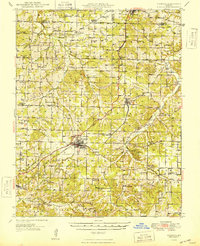
 1958 Springfield1958 Print · USGSThe Missouri Ozarks are captured during the mid-century era of growth, centered on the bustling hub of Springfield. Genealogists and historians can trace family roots through numerous landmarks like Ebenezer Church, Stockton Cem, and the various county courthouses.
 - 1959 Map of Springfield
 1959 Springfield1959 Print · USGSThe Missouri Ozarks are captured here during a decade of postwar growth and increasing highway connectivity. Researchers can trace the legacy of the St Louis-San Francisco RR and locate early sites in Springfield, Lebanon, and Mountain Grove.
 - 1982 Map of Niangua, 1983 Print
 1982 Niangua1983 Print · USGSThis part of Webster and Laclede counties in the early eighties shows a landscape of small Ozark settlements and timbered state lands. Researchers can locate family landmarks like Letterman Cem, the village of Niangua, and rural churches such as Mathis Ch.
 - 1982 Map of Phillipsburg, 1983 Print
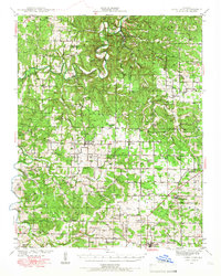
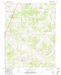
 1982 Phillipsburg1983 Print · USGSPhillipsburg and Conway are captured in the early eighties as the railroad still serves as a central artery for these Missouri communities. Researchers can locate numerous family-named landmarks and rural burial sites like Shanks Cem, Lonesome Hill Cem, and Mt Zion Ch.
 - 1982 Map of Lebanon, 1983 Print
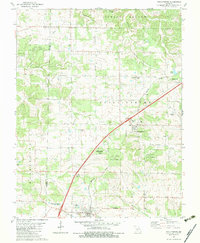
 1982 Lebanon1983 Print · USGSThe Missouri Ozarks are captured in the early eighties as Interstate 44 and the St Louis-San Francisco rail line link growing towns with the Fort Leonard Wood Military Reservation. Genealogists and historians can trace family-named sites like Flatwood Church and old post offices at Sleeper and Nebo.
 - 1983 Map of Mountain Grove
 1983 Mountain Grove1983 Print · USGSWright and Webster counties in the early 1980s show a traditional Ozark landscape of ridge-running railroads and river headwaters. You can trace the Burlington Northern Railroad through towns like Mansfield or find rural landmarks like Vance Cem and Mt Zion Church.
End of results
Showing maps 1-11 of 11
Top cities near Conway
- Lebanon historical maps
- Marshfield historical maps
- Niangua historical maps
- Phillipsburg historical maps
- Evergreen historical maps
- Caffeyville historical maps
Frequently asked questions
- What are the different types of historical maps available for Conway?
- What is the oldest map of Conway?
- Where can I purchase historical maps of Conway for my home or office?
- Where can I download high-res historical maps of Conway?
- Are there historical topographic maps available for Conway?
- Is there historical aerial imagery available for Conway?
- Where are historical maps of Conway sourced from?