1900s (20th Century) Maps of Evergreen, Missouri
Explore 10 historic maps of Evergreen from the 1900s (20th Century). These maps offer a rare glimpse into what life looked like during the 1900s — showing old roads, neighborhoods, homes, and landmarks that have changed or disappeared over time.
Whether you're researching your family's past, planning a metal detecting trip, or studying how Evergreen's landscape evolved across the 1900s, these high-resolution maps are a powerful tool for exploring the history of this region.
- Focus on a specific era: All maps on this page are from the 1900s, giving you a focused view of this time period.
- See what’s changed: Compare century-old streets, trails, and buildings to today's modern landscape using overlays and satellite layers.
- Research with precision: Use these maps for genealogy, historical research, land use analysis, or educational projects.
- View, download, or print: Maps are fully viewable online in high resolution, and can be downloaded or printed for your own records.
Start exploring Evergreen's history through authentic maps from the 1900s. This is your window into the past.
Evergreen, MO maps
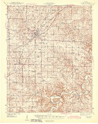
(10)- 1941 Map of Lebanon, 1968 Print
 1941 Lebanon1968 Print · USGSLebanon and the surrounding Laclede County uplands are captured here in the early 1940s, just as the region was defined by Route 66 and a network of one-room schools. Genealogists can locate family landmarks like Atchley Cem and Santiago Cem, or trace vanished rural hubs such as Caffeyville and Orla.
 - 1943 Map of Lebanon
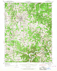
 1943 Lebanon1943 Print · USGSLaclede County at the start of the 1940s reveals a landscape where the St Louis San Francisco railway and early aviation at Lebanon Airport met deep-rooted Ozark settlements. Genealogists can trace family footprints across dozens of local landmarks like Roper Cem, Hough Chapel, and the Bear Thicket Sch.2 unique versions available
 - 1954 Map of Springfield
 1954 Springfield1954 Print · USGSThe Missouri Ozarks are captured here during the post-war era, showing the expansion of Springfield and the surrounding river valleys. Genealogists and historians can trace local landmarks like Mount Comfort Cemetery and the Fort Leonard Wood military grounds.6 unique versions available
 - 1958 Map of Springfield
 1958 Springfield1958 Print · USGSThe Missouri Ozarks are captured during the mid-century era of growth, centered on the bustling hub of Springfield. Genealogists and historians can trace family roots through numerous landmarks like Ebenezer Church, Stockton Cem, and the various county courthouses.
 - 1959 Map of Springfield
 1959 Springfield1959 Print · USGSThe Missouri Ozarks are captured here during a decade of postwar growth and increasing highway connectivity. Researchers can trace the legacy of the St Louis-San Francisco RR and locate early sites in Springfield, Lebanon, and Mountain Grove.
 - 1975 Map of Lebanon SW, 1976 Print
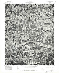 1975 Lebanon SW1976 Print · USGSMid-seventies Laclede County comes into focus in this detailed aerial survey of the Missouri countryside. Researchers can trace the winding path of Brush Creek and examine the rural layout surrounding the settlement at Morgan.
 - 1975 Map of Lebanon SE, 1976 Print
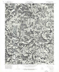 1975 Lebanon SE1976 Print · USGSLaclede County farmsteads and timberlands are captured from above in the mid-1970s, showing the rural landscape just south of Lebanon. Researchers can trace land use patterns along the winding Osage Fork and locate the small crossroads community of Russ.
 - 1979 Map of Russ, 1980 Print
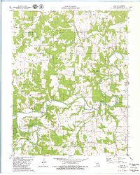 1979 Russ1980 Print · USGSLaclede County at the end of the 1970s reveals a landscape defined by the winding Osage Fork Gasconade River and secluded hollows. Genealogists and local historians can locate remote family sites like Sharpe Cem, the crossroads at Orla, and several prominent caverns including Saltpeter Cave.
 - 1979 Map of Brush Creek, 1980 Print
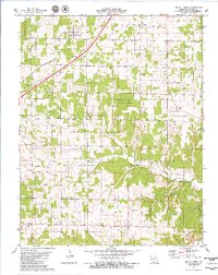 1979 Brush Creek1980 Print · USGSLaclede County in the late seventies is captured here, showing the rural communities and forest lands between Lebanon and Phillipsburg. Genealogists can trace family landmarks like Kissee Cem and Roper Cem or find the remote Bear Thicket Ch.
 - 1982 Map of Lebanon, 1983 Print
 1982 Lebanon1983 Print · USGSThe Missouri Ozarks are captured in the early eighties as Interstate 44 and the St Louis-San Francisco rail line link growing towns with the Fort Leonard Wood Military Reservation. Genealogists and historians can trace family-named sites like Flatwood Church and old post offices at Sleeper and Nebo.
End of results
Showing maps 1-10 of 10
Top cities near Evergreen
- Lebanon historical maps
- Conway historical maps
- Phillipsburg historical maps
- Caffeyville historical maps
Frequently asked questions
- What are the different types of historical maps available for Evergreen?
- What is the oldest map of Evergreen?
- Where can I purchase historical maps of Evergreen for my home or office?
- Where can I download high-res historical maps of Evergreen?
- Are there historical topographic maps available for Evergreen?
- Is there historical aerial imagery available for Evergreen?
- Where are historical maps of Evergreen sourced from?