1970s Maps of Evergreen, Missouri
Explore 4 historic maps of Evergreen from the 1970s. These maps offer a rare glimpse into what life looked like during the 1970s — showing old roads, neighborhoods, homes, and landmarks that have changed or disappeared over time.
Whether you're researching your family's past, planning a metal detecting trip, or studying how Evergreen's landscape evolved across the 1970s, these high-resolution maps are a powerful tool for exploring the history of this region.
- Focus on a specific era: All maps on this page are from the 1970s, giving you a focused view of this time period.
- See what’s changed: Compare century-old streets, trails, and buildings to today's modern landscape using overlays and satellite layers.
- Research with precision: Use these maps for genealogy, historical research, land use analysis, or educational projects.
- View, download, or print: Maps are fully viewable online in high resolution, and can be downloaded or printed for your own records.
Start exploring Evergreen's history through authentic maps from the 1970s. This is your window into the past.
Evergreen, MO maps
(4)- 1975 Map of Lebanon SW, 1976 Print
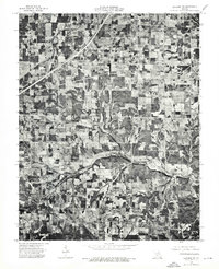 1975 Lebanon SW1976 Print · USGSMid-seventies Laclede County comes into focus in this detailed aerial survey of the Missouri countryside. Researchers can trace the winding path of Brush Creek and examine the rural layout surrounding the settlement at Morgan.
 - 1975 Map of Lebanon SE, 1976 Print
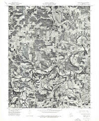 1975 Lebanon SE1976 Print · USGSLaclede County farmsteads and timberlands are captured from above in the mid-1970s, showing the rural landscape just south of Lebanon. Researchers can trace land use patterns along the winding Osage Fork and locate the small crossroads community of Russ.
 - 1979 Map of Russ, 1980 Print
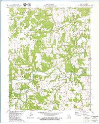 1979 Russ1980 Print · USGSLaclede County at the end of the 1970s reveals a landscape defined by the winding Osage Fork Gasconade River and secluded hollows. Genealogists and local historians can locate remote family sites like Sharpe Cem, the crossroads at Orla, and several prominent caverns including Saltpeter Cave.
 - 1979 Map of Brush Creek, 1980 Print
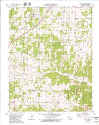 1979 Brush Creek1980 Print · USGSLaclede County in the late seventies is captured here, showing the rural communities and forest lands between Lebanon and Phillipsburg. Genealogists can trace family landmarks like Kissee Cem and Roper Cem or find the remote Bear Thicket Ch.
End of results
Showing maps 1-4 of 4
Top cities near Evergreen
- Lebanon historical maps
- Conway historical maps
- Phillipsburg historical maps
- Caffeyville historical maps
Frequently asked questions
- What are the different types of historical maps available for Evergreen?
- What is the oldest map of Evergreen?
- Where can I purchase historical maps of Evergreen for my home or office?
- Where can I download high-res historical maps of Evergreen?
- Are there historical topographic maps available for Evergreen?
- Is there historical aerial imagery available for Evergreen?
- Where are historical maps of Evergreen sourced from?