1930s Maps of Grace, Missouri
Explore 2 historic maps of Grace from the 1930s. These maps offer a rare glimpse into what life looked like during the 1930s — showing old roads, neighborhoods, homes, and landmarks that have changed or disappeared over time.
Whether you're researching your family's past, planning a metal detecting trip, or studying how Grace's landscape evolved across the 1930s, these high-resolution maps are a powerful tool for exploring the history of this region.
- Focus on a specific era: All maps on this page are from the 1930s, giving you a focused view of this time period.
- See what’s changed: Compare century-old streets, trails, and buildings to today's modern landscape using overlays and satellite layers.
- Research with precision: Use these maps for genealogy, historical research, land use analysis, or educational projects.
- View, download, or print: Maps are fully viewable online in high resolution, and can be downloaded or printed for your own records.
Start exploring Grace's history through authentic maps from the 1930s. This is your window into the past.
Grace, MO maps
(2)- 1933 Map of Stoutland, 1962 Print
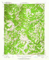 1933 Stoutland1962 Print · USGSThe Missouri Ozarks during the 1930s are captured here as a landscape of isolated hollows and rail-connected towns. Researchers can trace the St Louis San Francisco railroad line through Stoutland or locate family sites like Bradshaw Cem and Merchant Sch.2 unique versions available
 - 1938 Map of Stoutland
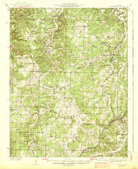 1938 Stoutland1938 Print · USGSThe Missouri Ozarks are captured here during the 1930s, showing a landscape of ridge-top farms and creek-bottom settlements. Researchers can trace the heritage of Camden and Laclede counties through sites like Ozark Fisheries, Darrow Cem, and Stoutland.
End of results
Showing maps 1-2 of 2
Top cities near Grace
- Lebanon historical maps
- Camdenton historical maps
- Linn Creek historical maps
- Macks Creek historical maps
Frequently asked questions
- What are the different types of historical maps available for Grace?
- What is the oldest map of Grace?
- Where can I purchase historical maps of Grace for my home or office?
- Where can I download high-res historical maps of Grace?
- Are there historical topographic maps available for Grace?
- Is there historical aerial imagery available for Grace?
- Where are historical maps of Grace sourced from?