1970s Maps of Lebanon, Missouri
Explore 4 historic maps of Lebanon from the 1970s. These maps offer a rare glimpse into what life looked like during the 1970s — showing old roads, neighborhoods, homes, and landmarks that have changed or disappeared over time.
Whether you're researching your family's past, planning a metal detecting trip, or studying how Lebanon's landscape evolved across the 1970s, these high-resolution maps are a powerful tool for exploring the history of this region.
- Focus on a specific era: All maps on this page are from the 1970s, giving you a focused view of this time period.
- See what’s changed: Compare century-old streets, trails, and buildings to today's modern landscape using overlays and satellite layers.
- Research with precision: Use these maps for genealogy, historical research, land use analysis, or educational projects.
- View, download, or print: Maps are fully viewable online in high resolution, and can be downloaded or printed for your own records.
Start exploring Lebanon's history through authentic maps from the 1970s. This is your window into the past.
Lebanon, MO maps
(4)- 1975 Map of Lebanon NE, 1976 Print
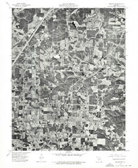 1975 Lebanon NE1976 Print · USGSLaclede County farmland and the Missouri interior are captured in this mid-seventies aerial study. Genealogists and local historians can trace the rural landscape surrounding Oakland and the wooded drainage of Mill Creek exactly as they appeared decades ago.
 - 1975 Map of Lebanon NW, 1976 Print
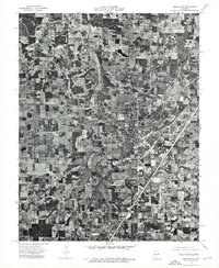 1975 Lebanon NW1976 Print · USGSMid-century Missouri development is frozen in time on this 1975 aerial survey of the Laclede County area. Researchers can trace the exact footprint of Lebanon and the rural agricultural patterns along Goodwin Hollow as they appeared fifty years ago.
 - 1978 Map of Lebanon
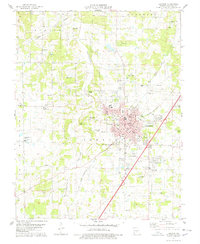 1978 Lebanon1978 Print · USGSLebanon and the surrounding Laclede County landscape are captured here in the late seventies as the town expanded along the rail corridor. Genealogists can trace family names through landmarks like Atchley Cem, Emmanuel Chapel, and the Joel E Barber Sch.
 - 1979 Map of Oakland, 1980 Print
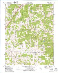 1979 Oakland1980 Print · USGSLaclede County in the late seventies is a landscape of established state forests and traditional country churches. Genealogists can trace family names through landmarks like Jarrell Cem and Thomas Chapel or follow the route of the St Louis-San Francisco Railroad.
End of results
Showing maps 1-4 of 4
Top cities near Lebanon
- Conway historical maps
- Phillipsburg historical maps
- Evergreen historical maps
- Caffeyville historical maps
Top neighborhoods of Lebanon
Frequently asked questions
- What are the different types of historical maps available for Lebanon?
- What is the oldest map of Lebanon?
- Where can I purchase historical maps of Lebanon for my home or office?
- Where can I download high-res historical maps of Lebanon?
- Are there historical topographic maps available for Lebanon?
- Is there historical aerial imagery available for Lebanon?
- Where are historical maps of Lebanon sourced from?