1970s Maps of Troy, Missouri
Explore 4 historic maps of Troy from the 1970s. These maps offer a rare glimpse into what life looked like during the 1970s — showing old roads, neighborhoods, homes, and landmarks that have changed or disappeared over time.
Whether you're researching your family's past, planning a metal detecting trip, or studying how Troy's landscape evolved across the 1970s, these high-resolution maps are a powerful tool for exploring the history of this region.
- Focus on a specific era: All maps on this page are from the 1970s, giving you a focused view of this time period.
- See what’s changed: Compare century-old streets, trails, and buildings to today's modern landscape using overlays and satellite layers.
- Research with precision: Use these maps for genealogy, historical research, land use analysis, or educational projects.
- View, download, or print: Maps are fully viewable online in high resolution, and can be downloaded or printed for your own records.
Start exploring Troy's history through authentic maps from the 1970s. This is your window into the past.
Troy, MO maps
(4)- 1972 Map of Troy, 1973 Print
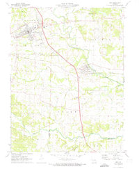 1972 Troy1973 Print · USGSLincoln County in the early 1970s reveals a landscape where modern development met historic rail and river corridors. Researchers can trace family roots at Sand Run Ch or Bray Cem, and explore the path of the Old Railroad Grade near Moscow Mills.3 unique versions available
 - 1973 Map of Warrenton NE, 1974 Print
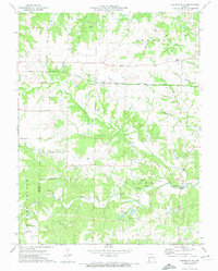 1973 Warrenton NE1974 Print · USGSThe rural borderlands of Lincoln and Warren counties come into focus during the early seventies, showcasing a landscape of family farms and creek valleys. Genealogists and local historians can trace legacy sites like the Old Davis Cem, Big Creek Community Center, and the Burlington Northern rail line.
 - 1975 Map of Okete, 1978 Print
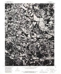
 1975 Okete1978 Print · USGSLincoln County in the mid-seventies shows a landscape of conservation and quiet rural life. Genealogists can locate numerous family burial grounds like Gladney Cem and Reid Cem or trace the early community centers of Okete and Brussels.2 unique versions available
 - 1979 Map of Troy, 1980 Print
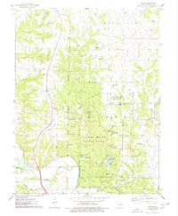
 1979 Troy1980 Print · USGSLincoln County comes into sharp focus in the late seventies as the expansion of Troy meets the agricultural traditions of the Cuivre River valley. Researchers can trace land divisions along the Fifth Principal Meridian or explore the mid-century layout of Moscow Mills.
End of results
Showing maps 1-4 of 4
Top cities near Troy
- O'Fallon historical maps
- Wentzville historical maps
- Warrenton historical maps
- Dardenne Prairie historical maps
- Wright City historical maps
- Elsberry historical maps
See more
Frequently asked questions
- What are the different types of historical maps available for Troy?
- What is the oldest map of Troy?
- Where can I purchase historical maps of Troy for my home or office?
- Where can I download high-res historical maps of Troy?
- Are there historical topographic maps available for Troy?
- Is there historical aerial imagery available for Troy?
- Where are historical maps of Troy sourced from?