1940s Maps of Wheeling, Missouri
Explore 1 historic maps of Wheeling from the 1940s. These maps offer a rare glimpse into what life looked like during the 1940s — showing old roads, neighborhoods, homes, and landmarks that have changed or disappeared over time.
Whether you're researching your family's past, planning a metal detecting trip, or studying how Wheeling's landscape evolved across the 1940s, these high-resolution maps are a powerful tool for exploring the history of this region.
- Focus on a specific era: All maps on this page are from the 1940s, giving you a focused view of this time period.
- See what’s changed: Compare century-old streets, trails, and buildings to today's modern landscape using overlays and satellite layers.
- Research with precision: Use these maps for genealogy, historical research, land use analysis, or educational projects.
- View, download, or print: Maps are fully viewable online in high resolution, and can be downloaded or printed for your own records.
Start exploring Wheeling's history through authentic maps from the 1940s. This is your window into the past.
Wheeling, MO maps
(1)- 1947 Map of Chula
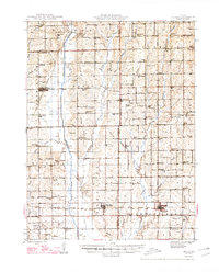 1947 Chula1947 Print · USGSNorth-central Missouri in the late 1940s is defined here by its rail-linked prairie towns and an incredible density of small country schoolhouses. Genealogists can trace family footprints across dozens of landmarks like Stucker Cemetery, Mt Gilead Church, and Jacksnipe School.3 unique versions available
End of results
Showing maps 1-1 of 1
Top cities near Wheeling
- Chillicothe historical maps
- Hale historical maps
- Meadville historical maps
- Blue Mound historical maps
- Laclede historical maps
- Linneus historical maps
See more
Frequently asked questions
- What are the different types of historical maps available for Wheeling?
- What is the oldest map of Wheeling?
- Where can I purchase historical maps of Wheeling for my home or office?
- Where can I download high-res historical maps of Wheeling?
- Are there historical topographic maps available for Wheeling?
- Is there historical aerial imagery available for Wheeling?
- Where are historical maps of Wheeling sourced from?