Old Maps of Livingston County, Missouri
Explore 116 old maps of Livingston County, spanning from 1921 to today. These high-resolution historic maps reveal how streets, neighborhoods, landmarks, and natural features evolved over time — perfect for genealogy, metal detecting, research, and local history exploration.
What you can do with these maps:
- See how Livingston County changed over time: Compare historical maps to modern-day views to trace roads, homesites, rail lines & more.
- View detailed metadata: Each map includes creators, publishers, year, scale, and archive source.
- Overlay maps with satellite & LiDAR: Visualize the past alongside modern tools to explore terrain & human change.
- Trusted historical sources: Maps sourced from the USGS, Library of Congress, and other archives.
- Access maps your way: View online, download high-res files, or order prints for personal or research use.
Start exploring old maps of Livingston County to uncover forgotten places, hidden landmarks, and the deep history beneath your feet.
Livingston County, MO maps
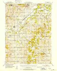
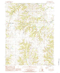
(116)- 1921 Map of Chillicothe, 1958 Print
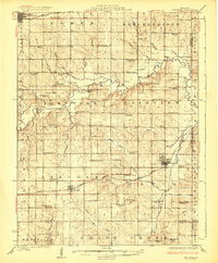
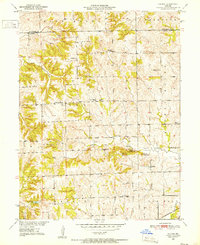
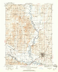 1921 Chillicothe1958 Print · USGSNorth-central Missouri at the start of the 1920s is a landscape of river-bottom farms and a bustling rail hub at the intersection of four major lines. Genealogists and researchers can trace dozens of country schoolhouses and early post offices like Hickory Creek P O, Lily Grove Church, and the Graham Mill Bridge.2 unique versions available
 - 1922 Map of Gallatin
 1922 Gallatin1922 Print · USGSDaviess and Caldwell Counties are shown here during the early twenties, when the Grand River and major railroads drove the local economy. Genealogists can trace hundreds of rural family sites anchored by Everly Cemetery, Centenary Church, and schools like Calfpen School.2 unique versions available
 - 1923 Map of Chillicothe
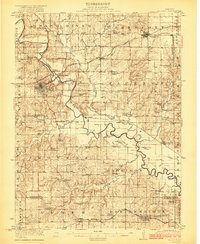
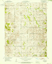
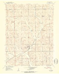
 1923 Chillicothe1923 Print · USGSThe Livingston County rail hub of Chillicothe is shown here in the early twenties at the height of its regional importance. Genealogists can trace dozens of rural school districts like Happy Hollow School and early centers like Hickory P O.2 unique versions available
 - 1924 Map of Dawn
 1924 Dawn1924 Print · USGSLivingston County's agricultural heartland is captured here in the mid-twenties, a landscape defined by small rail towns and one-room schoolhouses. Genealogists can locate family landmarks like Johnson School or Swain School along the busy Chicago Milwaukee and St. Paul rail line.4 unique versions available
 - 1924 Map of Braymer
 1924 Braymer1924 Print · USGSNorthwest Missouri's agricultural heartland is documented here in the early twenties, showing a landscape defined by the railroad and a dense grid of rural schoolhouses. Genealogists can locate specific family landmarks like Brown Jug School, Hopewell Church, and the Gould Farm Bridge.3 unique versions available
 - 1924 Map of Chula
 1924 Chula1924 Print · USGSNorth-central Missouri thrived as a rail-connected farming region in the early twentieth century. Researchers can trace dozens of rural schoolhouses and family plots, from Brush College School to the Plainview Cemetery near Chula.3 unique versions available
 - 1924 Map of Hale
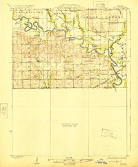 1924 Hale1924 Print · USGSThe Grand River valley in the early 1920s reveals a landscape of winding waterways and rail-connected settlements at the borders of Livingston and Carroll counties. Genealogists can locate numerous country schools like Lowland School and Morgan School, or trace family roots near Grace Church and Avalon.4 unique versions available
 - 1947 Map of Chula
 1947 Chula1947 Print · USGSNorth-central Missouri in the late 1940s is defined here by its rail-linked prairie towns and an incredible density of small country schoolhouses. Genealogists can trace family footprints across dozens of landmarks like Stucker Cemetery, Mt Gilead Church, and Jacksnipe School.3 unique versions available
 - 1950 Map of Coloma, 1952 Print
 1950 Coloma1952 Print · USGSThe rural landscape of Carroll County is captured here in the early fifties, showing a community structured around small schools and high prairie mounds. Researchers can find old landmarks like Coloma, the Locust Sch, and the unique triplet of Tater Hill, Long Tater Hill, and Round Tater Hill.3 unique versions available
 - 1950 Map of Plymouth, 1952 Print
 1950 Plymouth1952 Print · USGSNorthwestern Missouri was a landscape of small school districts and country churches at the mid-century. Genealogists can locate family-named landmarks like Rea Sch and Hanks Sch, or trace the community centers of Plymouth and Mt Tabor Ch.3 unique versions available
 - 1950 Map of Hale, 1956 Print
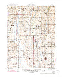
 1950 Hale1956 Print · USGSCarroll County was a landscape of river-bend lakes and rural schoolhouses in the mid-twentieth century. Genealogists can trace family footprints through sites like Elizabeth Cemetery or Hazel Hill School, while exploring the oxbows of the Grand River.2 unique versions available
 - 1951 Map of Hale
 1951 Hale1951 Print · USGSNorthwestern Missouri farming life and river management are preserved here in the early fifties. Genealogists can locate family landmarks like Elizabeth Cem, Winfrey Cem, and numerous rural schools including Battsville Sch.
 - 1951 Map of Utica, 1952 Print
 1951 Utica1952 Print · USGSLivingston and Carroll counties are mapped here in the early fifties, showing a landscape defined by the Grand River and thriving rail corridors. Researchers can trace dozens of rural school sites like McCleary Sch and family-named landmarks from Bunch Hollow to Tater Hill.
 - 1951 Map of Hale, 1952 Print
 1951 Hale1952 Print · USGSNorth-central Missouri's river lowlands are captured here in the early fifties, showing the area around Hale and the Grand River floodplain. Researchers can trace defunct rural infrastructure like Hazel Green Sch and the Sumner Bridge crossing.3 unique versions available
 - 1952 Map of Tina
 1952 Tina1952 Print · USGSCarroll County rural life in the early fifties is centered on the railroad village of Tina. Researchers can trace old family footprints through numerous country schoolhouses like Ironclad Sch and Round Grove Sch, or locate ancestral sites at Macklin Cem.3 unique versions available
 - 1953 Map of Moberly
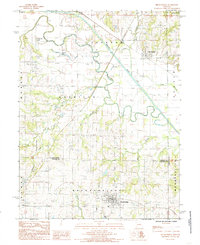
 1953 Moberly1953 Print · USGSMid-century north-central Missouri is documented here as a bustling intersection of river commerce and heavy rail. Researchers can trace historic family-named landmarks and transport hubs from the Missouri River corridor to the rail yards of Moberly, Chillicothe, and Macon.
 - 1954 Map of Moberly, 1969 Print
 1954 Moberly1969 Print · USGSMid-century Missouri is captured here during a period of transition for its river towns and rail hubs. Genealogists and historians can trace the paths of the Wabash railroad through Moberly or explore the riverside layout of Lexington and Brunswick.3 unique versions available
 - 1957 Map of Moberly
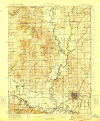
 1957 Moberly1957 Print · USGSNorth-central Missouri in the late nineteen-forties and fifties remains a landscape defined by its great rivers and a dense network of steam and diesel rail lines. Genealogists and historians can trace the paths of the Wabash RR and Santa Fe RR through historic junctions like Moberly, Brookfield, and Macon.
 - 1960 Map of Moberly
 1960 Moberly1960 Print · USGSCentral Missouri comes alive in the mid-twentieth century as a bustling network of river towns and significant rail corridors. Genealogists and historians can trace the paths of the Wabash RR through Moberly or explore the riverfronts of Lexington and Brunswick.
 - 1981 Map of Chillicothe
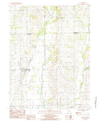
 1981 Chillicothe1981 Print · USGSNorth Missouri's Grand River basin comes into focus during the early 1980s, showcasing a network of vital rail lines and river settlements. Genealogists and historians can trace rail-town development from Gallatin to Brookfield and explore extensive conservation lands like Swan Lake National Wildlife Refuge.
 - 1983 Map of Chula, 1985 Print
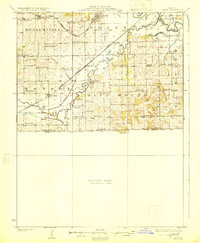
 1983 Chula1985 Print · USGSNorthwestern Missouri's agricultural heartland is documented here in the early 1980s, centered on the railroad town of Chula. Researchers can trace the path of the Chicago Milwaukee St Paul and Pacific rail line and locate old settlements like Alpha and Sturges.
 - 1984 Map of Utica East
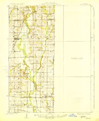
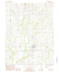
 1984 Utica East1984 Print · USGSLivingston County in the early 1980s was defined by its relationship with the Grand River and the rural townships of Green and Blue Mound. Genealogists and local historians can trace family locations near Utica, old country cemeteries, and waterways like Shoal Creek.
 - 1984 Map of Shearwood, 1985 Print
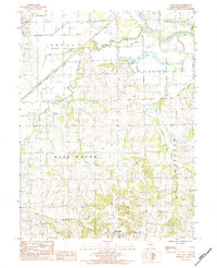
 1984 Shearwood1985 Print · USGSNorthwest of Chillicothe in the mid-1980s, this area of Missouri is characterized by the expansive Poosey State Forest and its creek-carved hills. Genealogists and researchers can locate old rural settlements like Shearwood and Springhill or find unnamed cemeteries tucked away in Jackson Township.
 - 1984 Map of Breckenridge, 1985 Print
 1984 Breckenridge1985 Print · USGSThe Caldwell County landscape in the 1980s is defined by the meandering waters and engineered levees of the Grand River. Researchers can trace the grid of Breckenridge, locate local Cem sites, and explore water bodies like Packwood Lake and S Lake.
 - 1984 Map of Meadville, 1985 Print
 1984 Meadville1985 Print · USGSMeadville sits at the center of this Linn County landscape during the mid-1980s, anchored by its proximity to the railroad. Genealogists and local historians can trace the rural property patterns near Parson Creek and the steel rails of the Burlington Northern.
Showing maps 1-25 of 116
Top cities of Livingston County
- Chillicothe historical maps
- Blue Mound historical maps
- Utica historical maps
- Wheeling historical maps
- Sampsel historical maps
- Ludlow historical maps
See more
Frequently asked questions
- What are the different types of historical maps available for Livingston County?
- What is the oldest map of Livingston County?
- Where can I purchase historical maps of Livingston County for my home or office?
- Where can I download high-res historical maps of Livingston County?
- Are there historical topographic maps available for Livingston County?
- Is there historical aerial imagery available for Livingston County?
- Where are historical maps of Livingston County sourced from?