1960s Maps of Macon County, Missouri
Explore 4 historic maps of Macon County from the 1960s. These maps offer a rare glimpse into what life looked like during the 1960s — showing old roads, neighborhoods, homes, and landmarks that have changed or disappeared over time.
Whether you're researching your family's past, planning a metal detecting trip, or studying how Macon County's landscape evolved across the 1960s, these high-resolution maps are a powerful tool for exploring the history of this region.
- Focus on a specific era: All maps on this page are from the 1960s, giving you a focused view of this time period.
- See what’s changed: Compare century-old streets, trails, and buildings to today's modern landscape using overlays and satellite layers.
- Research with precision: Use these maps for genealogy, historical research, land use analysis, or educational projects.
- View, download, or print: Maps are fully viewable online in high resolution, and can be downloaded or printed for your own records.
Start exploring Macon County's history through authentic maps from the 1960s. This is your window into the past.
Macon County, MO maps
(4)- 1960 Map of Moberly
 1960 Moberly1960 Print · USGSCentral Missouri comes alive in the mid-twentieth century as a bustling network of river towns and significant rail corridors. Genealogists and historians can trace the paths of the Wabash RR through Moberly or explore the riverfronts of Lexington and Brunswick.
 - 1963 Map of Nind, 1965 Print
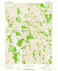 1963 Nind1965 Print · USGSNorth central Missouri agriculture and small-town life are documented here during the early sixties. Genealogists can locate family landmarks like Hall Cem, Mt Carmel Ch, and the rural Willow Branch Sch near the county lines.
 - 1965 Map of Locust Hill, 1967 Print
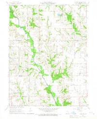 1965 Locust Hill1967 Print · USGSNortheast Missouri farmland meets the winding North Fork Salt River in this mid-sixties survey of the Knox County border. Genealogists and local historians can trace family ties at Locust Hill Cem or follow the path of the Old Railroad Grade.
 - 1966 Map of La Plata, 1967 Print
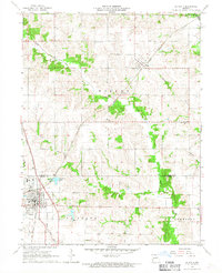 1966 La Plata1967 Print · USGSLa Plata and the surrounding Missouri countryside are captured in the mid-1960s at the height of its dual-railroad era. Researchers can trace the junction of the Atchison Topeka and Santa Fe and Norfolk and Western, alongside local landmarks like Santa Fe Lake and Gibbs Union Cem.
End of results
Showing maps 1-4 of 4
Top cities of Macon County
- Macon historical maps
- La Plata historical maps
- Bevier historical maps
- Callao historical maps
- New Cambria historical maps
- Ethel historical maps
See more
Frequently asked questions
- What are the different types of historical maps available for Macon County?
- What is the oldest map of Macon County?
- Where can I purchase historical maps of Macon County for my home or office?
- Where can I download high-res historical maps of Macon County?
- Are there historical topographic maps available for Macon County?
- Is there historical aerial imagery available for Macon County?
- Where are historical maps of Macon County sourced from?