1980s Maps of Wide Ford, Missouri
Explore 3 historic maps of Wide Ford from the 1980s. These maps offer a rare glimpse into what life looked like during the 1980s — showing old roads, neighborhoods, homes, and landmarks that have changed or disappeared over time.
Whether you're researching your family's past, planning a metal detecting trip, or studying how Wide Ford's landscape evolved across the 1980s, these high-resolution maps are a powerful tool for exploring the history of this region.
- Focus on a specific era: All maps on this page are from the 1980s, giving you a focused view of this time period.
- See what’s changed: Compare century-old streets, trails, and buildings to today's modern landscape using overlays and satellite layers.
- Research with precision: Use these maps for genealogy, historical research, land use analysis, or educational projects.
- View, download, or print: Maps are fully viewable online in high resolution, and can be downloaded or printed for your own records.
Start exploring Wide Ford's history through authentic maps from the 1980s. This is your window into the past.
Wide Ford, MO maps
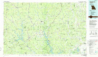
(3)- 1980 Map of Rock Pile Mountain
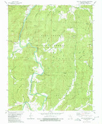 1980 Rock Pile Mountain1980 Print · USGSMadison County in the early eighties was a landscape of forested peaks and river valleys deeply etched by early settlement. Genealogists can trace family names through numerous burial sites like Shoemaker Cem and Berry Cem, or locate landmarks such as French Mills and Mt Pisgah Ch.
 - 1986 Map of Piedmont
 1986 Piedmont1986 Print · USGSThe Missouri Ozarks are captured here in the mid-eighties as a region of dense state forests and critical river management. Genealogists and historians can trace family-named features and rural settlements like Piedmont, Lesterville, and the Yokum School.2 unique versions available
 - 1989 Map of Rolla
 1989 Rolla1989 Print · USGSThe Missouri Ozarks are captured in the late eighties as a landscape of national forests and historic mining towns. Researchers can trace the rail lines of the Missouri Pacific RR or locate landmarks like Taum Sauk Mtn and Elephant Rocks State Park.
End of results
Showing maps 1-3 of 3
Top cities near Wide Ford
- Fredericktown historical maps
- Ironton historical maps
- Pilot Knob historical maps
- Arcadia historical maps
- Junction City historical maps
- Des Arc historical maps
Frequently asked questions
- What are the different types of historical maps available for Wide Ford?
- What is the oldest map of Wide Ford?
- Where can I purchase historical maps of Wide Ford for my home or office?
- Where can I download high-res historical maps of Wide Ford?
- Are there historical topographic maps available for Wide Ford?
- Is there historical aerial imagery available for Wide Ford?
- Where are historical maps of Wide Ford sourced from?