1930s Maps of Uva, Missouri
Explore 2 historic maps of Uva from the 1930s. These maps offer a rare glimpse into what life looked like during the 1930s — showing old roads, neighborhoods, homes, and landmarks that have changed or disappeared over time.
Whether you're researching your family's past, planning a metal detecting trip, or studying how Uva's landscape evolved across the 1930s, these high-resolution maps are a powerful tool for exploring the history of this region.
- Focus on a specific era: All maps on this page are from the 1930s, giving you a focused view of this time period.
- See what’s changed: Compare century-old streets, trails, and buildings to today's modern landscape using overlays and satellite layers.
- Research with precision: Use these maps for genealogy, historical research, land use analysis, or educational projects.
- View, download, or print: Maps are fully viewable online in high resolution, and can be downloaded or printed for your own records.
Start exploring Uva's history through authentic maps from the 1930s. This is your window into the past.
Uva, MO maps
(2)- 1932 Map of Hannibal
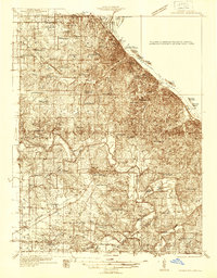
 1932 Hannibal1932 Print · USGSAlong the Mississippi River in the early 1930s, this survey captures the riverfront from Hannibal across to the Illinois bottomlands. Researchers can trace the river rail crossings of the WABASH and locate rural landmarks like Bird Slough Sch and the CHENALE ECARTE CLUB.4 unique versions available
 - 1936 Map of Hannibal
 1936 Hannibal1936 Print · USGSMid-century Hannibal and New London are shown during a transitional era of river commerce and early aviation. Researchers can trace the paths of the Burlington railroad or find ancestral landmarks like Withers Mill and Mt Olivet Cem.2 unique versions available
End of results
Showing maps 1-2 of 2
Top cities near Uva
- Quincy historical maps
- Hannibal historical maps
- Palmyra historical maps
- Payson historical maps
- New London historical maps
- Burton historical maps
See more
Frequently asked questions
- What are the different types of historical maps available for Uva?
- What is the oldest map of Uva?
- Where can I purchase historical maps of Uva for my home or office?
- Where can I download high-res historical maps of Uva?
- Are there historical topographic maps available for Uva?
- Is there historical aerial imagery available for Uva?
- Where are historical maps of Uva sourced from?