1930s Maps of Miller County, Missouri
Explore 8 historic maps of Miller County from the 1930s. These maps offer a rare glimpse into what life looked like during the 1930s — showing old roads, neighborhoods, homes, and landmarks that have changed or disappeared over time.
Whether you're researching your family's past, planning a metal detecting trip, or studying how Miller County's landscape evolved across the 1930s, these high-resolution maps are a powerful tool for exploring the history of this region.
- Focus on a specific era: All maps on this page are from the 1930s, giving you a focused view of this time period.
- See what’s changed: Compare century-old streets, trails, and buildings to today's modern landscape using overlays and satellite layers.
- Research with precision: Use these maps for genealogy, historical research, land use analysis, or educational projects.
- View, download, or print: Maps are fully viewable online in high resolution, and can be downloaded or printed for your own records.
Start exploring Miller County's history through authentic maps from the 1930s. This is your window into the past.
Miller County, MO maps
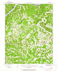
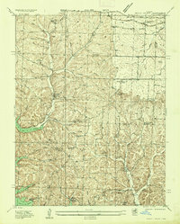
(8)- 1932 Map of Versailles No 4
 1932 Versailles No 41932 Print · USGSThe Missouri Ozarks are captured here in the early 1930s, showing the early transformation of the landscape following the creation of Lake of the Ozarks. Researchers can trace the roots of Osage Beach or locate rural landmarks like Popplewell Cem and Watson Sch.
 - 1933 Map of Iberia, 1963 Print
 1933 Iberia1963 Print · USGSThe Osage River hills during the early 1930s reveal a landscape of isolated farmsteads and rural schoolhouses. Genealogists can trace family roots through numerous sites like Ramsey Cem, Gott Ch, and vanished school districts like Stumpf Sch.2 unique versions available
 - 1934 Map of Toronto
 1934 Toronto1934 Print · USGSMissouri's lake country was in its early years of transformation during the 1930s as new shorelines met established rural communities. Genealogists can locate family landmarks like Auglaize Cem or trace rural education at Snider School and Jefferies School.
 - 1934 Map of Lake Ozark
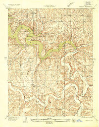
 1934 Lake Ozark1934 Print · USGSThe new reservoir era in Central Missouri comes to life in this survey, showing the shoreline just after the completion of Bagnell Dam. Researchers can trace the early developments at Lakeview Beach and locate rural landmarks like Harpers Chapel and Zebra PO.3 unique versions available
 - 1934 Map of Bagnell
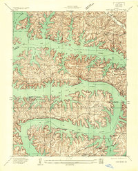
 1934 Bagnell1934 Print · USGSThe Lake of the Ozarks region is captured here during the transformative mid-1930s, just after the completion of the massive Bagnell Dam. Researchers can trace rural life through the locations of the Fitzgerald Cem, Bennett Ch, and early river crossings like the Ferry near Wilcox Bend.
 - 1935 Map of Rocky Mount
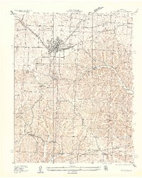
 1935 Rocky Mount1935 Print · USGSThe Morgan and Miller County borderlands are shown here in the mid-1930s as the northern arms of the Lake of the Ozarks began to shape the terrain. Researchers can locate rural landmarks like the Stover Coal Bank, the Rocky Mount PO, and several family cemeteries.
 - 1935 Map of Eldon
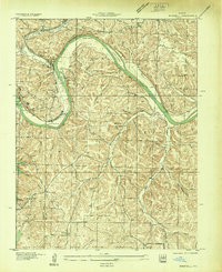
 1935 Eldon1935 Print · USGSMiller County's rail and ridge lands are captured here in the mid-1930s as Eldon grew around the Chicago Rock Island and Pacific tracks. Researchers can trace the footprint of early rural education at Franklin School or locate family plots at Salem Cem and Vaughn Cem.2 unique versions available
 - 1937 Map of Iberia
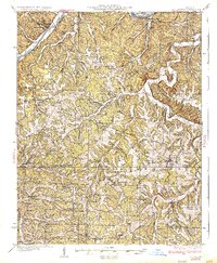 1937 Iberia1937 Print · USGSIberia and the surrounding Miller County hills are captured here in the mid-1930s, showing a landscape of small farms and crossroads communities. Genealogists can trace family footprints at Ramsey Cem, Twelve Corners Ch, and dozens of rural school sites like Barton Sch.2 unique versions available
End of results
Showing maps 1-8 of 8
Top cities of Miller County
- Eldon historical maps
- Lake Ozark historical maps
- Iberia historical maps
- Tuscumbia historical maps
- Olean historical maps
- Brumley historical maps
See more
Frequently asked questions
- What are the different types of historical maps available for Miller County?
- What is the oldest map of Miller County?
- Where can I purchase historical maps of Miller County for my home or office?
- Where can I download high-res historical maps of Miller County?
- Are there historical topographic maps available for Miller County?
- Is there historical aerial imagery available for Miller County?
- Where are historical maps of Miller County sourced from?