1940s Maps of Etterville, Missouri
Explore 2 historic maps of Etterville from the 1940s. These maps offer a rare glimpse into what life looked like during the 1940s — showing old roads, neighborhoods, homes, and landmarks that have changed or disappeared over time.
Whether you're researching your family's past, planning a metal detecting trip, or studying how Etterville's landscape evolved across the 1940s, these high-resolution maps are a powerful tool for exploring the history of this region.
- Focus on a specific era: All maps on this page are from the 1940s, giving you a focused view of this time period.
- See what’s changed: Compare century-old streets, trails, and buildings to today's modern landscape using overlays and satellite layers.
- Research with precision: Use these maps for genealogy, historical research, land use analysis, or educational projects.
- View, download, or print: Maps are fully viewable online in high resolution, and can be downloaded or printed for your own records.
Start exploring Etterville's history through authentic maps from the 1940s. This is your window into the past.
Etterville, MO maps
(2)- 1947 Map of Jefferson City, 1949 Print
 1947 Jefferson City1949 Print · USGSCentral Missouri and the northern Ozarks come into focus in this late 1940s survey of the river-and-rail landscape. Genealogists and historians can trace the growth of Jefferson City and Sedalia or locate family roots near Bagnell Dam and the Lake of the Ozarks.
 - 1948 Map of Eugene, 1966 Print
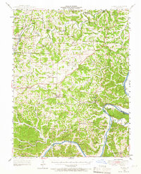 1948 Eugene1966 Print · USGSCentral Missouri rural life is captured here in the years following the war, centered on the rail corridor through Eugene. Researchers can trace family sites and community landmarks like Marys Home, Rush Chapel, and the river bluffs along the Osage River.2 unique versions available
End of results
Showing maps 1-2 of 2
Top cities near Etterville
- Jefferson City historical maps
- Eldon historical maps
- Osage Beach historical maps
- Four Seasons historical maps
- Lake Ozark historical maps
- Russellville historical maps
See more
Frequently asked questions
- What are the different types of historical maps available for Etterville?
- What is the oldest map of Etterville?
- Where can I purchase historical maps of Etterville for my home or office?
- Where can I download high-res historical maps of Etterville?
- Are there historical topographic maps available for Etterville?
- Is there historical aerial imagery available for Etterville?
- Where are historical maps of Etterville sourced from?