1970s Maps of Dorena Landing, Missouri
Explore 2 historic maps of Dorena Landing from the 1970s. These maps offer a rare glimpse into what life looked like during the 1970s — showing old roads, neighborhoods, homes, and landmarks that have changed or disappeared over time.
Whether you're researching your family's past, planning a metal detecting trip, or studying how Dorena Landing's landscape evolved across the 1970s, these high-resolution maps are a powerful tool for exploring the history of this region.
- Focus on a specific era: All maps on this page are from the 1970s, giving you a focused view of this time period.
- See what’s changed: Compare century-old streets, trails, and buildings to today's modern landscape using overlays and satellite layers.
- Research with precision: Use these maps for genealogy, historical research, land use analysis, or educational projects.
- View, download, or print: Maps are fully viewable online in high resolution, and can be downloaded or printed for your own records.
Start exploring Dorena Landing's history through authentic maps from the 1970s. This is your window into the past.
Dorena Landing, MO maps
(2)- 1970 Map of Hickman, 1972 Print
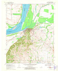 1970 Hickman1972 Print · USGSThe riverfront at Hickman and the surrounding Kentucky-Tennessee borderlands are shown here during the early seventies. Genealogists and local historians can trace family sites at Hubbard Cem, visit Anna Lynne, or follow the Illinois Central Railroad line.2 unique versions available
 - 1972 Map of Hickman
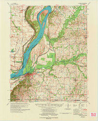 1972 Hickman1972 Print · USGSThe Kentucky and Tennessee borderlands come alive in the early 1970s, as the mighty Mississippi winds past riverfront settlements. Researchers can trace the Illinois Central rail line through rural hubs like Moscow and Cayce, or locate family landmarks such as Mt Hermon Ch and Ivie Cem.
End of results
Showing maps 1-2 of 2
Top cities near Dorena Landing
- Union City historical maps
- East Prairie historical maps
- Hickman historical maps
- Clinton historical maps
- Troy historical maps
- Arlington historical maps
See more
Frequently asked questions
- What are the different types of historical maps available for Dorena Landing?
- What is the oldest map of Dorena Landing?
- Where can I purchase historical maps of Dorena Landing for my home or office?
- Where can I download high-res historical maps of Dorena Landing?
- Are there historical topographic maps available for Dorena Landing?
- Is there historical aerial imagery available for Dorena Landing?
- Where are historical maps of Dorena Landing sourced from?