1930s Maps of Whiting, Missouri
Explore 1 historic maps of Whiting from the 1930s. These maps offer a rare glimpse into what life looked like during the 1930s — showing old roads, neighborhoods, homes, and landmarks that have changed or disappeared over time.
Whether you're researching your family's past, planning a metal detecting trip, or studying how Whiting's landscape evolved across the 1930s, these high-resolution maps are a powerful tool for exploring the history of this region.
- Focus on a specific era: All maps on this page are from the 1930s, giving you a focused view of this time period.
- See what’s changed: Compare century-old streets, trails, and buildings to today's modern landscape using overlays and satellite layers.
- Research with precision: Use these maps for genealogy, historical research, land use analysis, or educational projects.
- View, download, or print: Maps are fully viewable online in high resolution, and can be downloaded or printed for your own records.
Start exploring Whiting's history through authentic maps from the 1930s. This is your window into the past.
Whiting, MO maps
(1)- 1939 Map of Charleston, 1941 Print
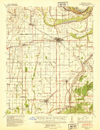 1939 Charleston1941 Print · USGSThe Missouri Bootheel near Charleston is shown here just as the modern levee and ditch systems were taking final shape. Researchers can trace the era's rural social fabric through numerous local landmarks like Pulltight Sch, Maynard Cem, and the St Louis Southwestern rail line.2 unique versions available
End of results
Showing maps 1-1 of 1
Top cities near Whiting
- Sikeston historical maps
- Charleston historical maps
- East Prairie historical maps
- New Madrid historical maps
- Cairo historical maps
- Hickman historical maps
See more
Frequently asked questions
- What are the different types of historical maps available for Whiting?
- What is the oldest map of Whiting?
- Where can I purchase historical maps of Whiting for my home or office?
- Where can I download high-res historical maps of Whiting?
- Are there historical topographic maps available for Whiting?
- Is there historical aerial imagery available for Whiting?
- Where are historical maps of Whiting sourced from?