1960s Maps of Marvin, Missouri
Explore 2 historic maps of Marvin from the 1960s. These maps offer a rare glimpse into what life looked like during the 1960s — showing old roads, neighborhoods, homes, and landmarks that have changed or disappeared over time.
Whether you're researching your family's past, planning a metal detecting trip, or studying how Marvin's landscape evolved across the 1960s, these high-resolution maps are a powerful tool for exploring the history of this region.
- Focus on a specific era: All maps on this page are from the 1960s, giving you a focused view of this time period.
- See what’s changed: Compare century-old streets, trails, and buildings to today's modern landscape using overlays and satellite layers.
- Research with precision: Use these maps for genealogy, historical research, land use analysis, or educational projects.
- View, download, or print: Maps are fully viewable online in high resolution, and can be downloaded or printed for your own records.
Start exploring Marvin's history through authentic maps from the 1960s. This is your window into the past.
Marvin, MO maps
(2)- 1961 Map of Versailles
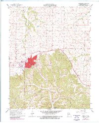 1961 Versailles1961 Print · USGSVersailles and the surrounding Morgan County countryside are shown here during a period of steady mid-century growth and infrastructure development. Genealogists and local historians can trace rural family roots through landmarks like Mt Zion Ch, the settlement at Marvin, and James Mill Spring.4 unique versions available
 - 1961 Map of Gravois Mills, 1965 Print
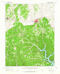 1961 Gravois Mills1965 Print · USGSMorgan County is shown in the early sixties as the regional landscape adjusted to the presence of the Lake of the Ozarks. Trace the Chicago Rock Island and Pacific rail line between Stover and Versailles or locate family sites like Antioch Cem and the Wolf Den Mine.
End of results
Showing maps 1-2 of 2
Top cities near Marvin
- Eldon historical maps
- California historical maps
- Versailles historical maps
- Four Seasons historical maps
- Lake Ozark historical maps
- Stover historical maps
See more
Frequently asked questions
- What are the different types of historical maps available for Marvin?
- What is the oldest map of Marvin?
- Where can I purchase historical maps of Marvin for my home or office?
- Where can I download high-res historical maps of Marvin?
- Are there historical topographic maps available for Marvin?
- Is there historical aerial imagery available for Marvin?
- Where are historical maps of Marvin sourced from?