1970s Maps of Stancil, Missouri
Explore 2 historic maps of Stancil from the 1970s. These maps offer a rare glimpse into what life looked like during the 1970s — showing old roads, neighborhoods, homes, and landmarks that have changed or disappeared over time.
Whether you're researching your family's past, planning a metal detecting trip, or studying how Stancil's landscape evolved across the 1970s, these high-resolution maps are a powerful tool for exploring the history of this region.
- Focus on a specific era: All maps on this page are from the 1970s, giving you a focused view of this time period.
- See what’s changed: Compare century-old streets, trails, and buildings to today's modern landscape using overlays and satellite layers.
- Research with precision: Use these maps for genealogy, historical research, land use analysis, or educational projects.
- View, download, or print: Maps are fully viewable online in high resolution, and can be downloaded or printed for your own records.
Start exploring Stancil's history through authentic maps from the 1970s. This is your window into the past.
Stancil, MO maps
(2)- 1971 Map of Stanley, 1973 Print
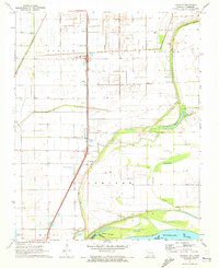 1971 Stanley1973 Print · USGSIn the early 1970s, this Mississippi River borderland shows a landscape of productive farm townships and riverside bayous. Researchers can locate family landmarks like Stancil Cem, Averill Cem, and the settlement of Concord.2 unique versions available
 - 1973 Map of Portageville
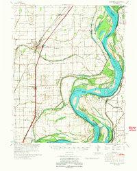 1973 Portageville1973 Print · USGSThe Missouri Bootheel near Portageville was a landscape of intensive drainage and river commerce in the early seventies. Genealogists and local historians can trace family burial sites like Kimes Cem and rural landmarks such as North Pemiscot Sch.
End of results
Showing maps 1-2 of 2
Top cities near Stancil
- Caruthersville historical maps
- Tiptonville historical maps
- New Madrid historical maps
- Hayti historical maps
- Ridgely historical maps
- Hayti Heights historical maps
See more
Frequently asked questions
- What are the different types of historical maps available for Stancil?
- What is the oldest map of Stancil?
- Where can I purchase historical maps of Stancil for my home or office?
- Where can I download high-res historical maps of Stancil?
- Are there historical topographic maps available for Stancil?
- Is there historical aerial imagery available for Stancil?
- Where are historical maps of Stancil sourced from?