1990s Maps of Menfro, Missouri
Explore 1 historic maps of Menfro from the 1990s. These maps offer a rare glimpse into what life looked like during the 1990s — showing old roads, neighborhoods, homes, and landmarks that have changed or disappeared over time.
Whether you're researching your family's past, planning a metal detecting trip, or studying how Menfro's landscape evolved across the 1990s, these high-resolution maps are a powerful tool for exploring the history of this region.
- Focus on a specific era: All maps on this page are from the 1990s, giving you a focused view of this time period.
- See what’s changed: Compare century-old streets, trails, and buildings to today's modern landscape using overlays and satellite layers.
- Research with precision: Use these maps for genealogy, historical research, land use analysis, or educational projects.
- View, download, or print: Maps are fully viewable online in high resolution, and can be downloaded or printed for your own records.
Start exploring Menfro's history through authentic maps from the 1990s. This is your window into the past.
Menfro, MO maps
(1)- 1994 Map of Rockwood, 1996 Print
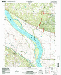 1994 Rockwood1996 Print · USGSThe riverfront communities of Randolph and Jackson counties come into focus during the 1990s as they navigate the shifting Mississippi River bottomlands. Genealogists can trace numerous family burial sites like Woods Cemetery and Hindman Cemetery near Rockwood.2 unique versions available
End of results
Showing maps 1-1 of 1
Top cities near Menfro
- Perryville historical maps
- Chester historical maps
- Steeleville historical maps
- Willisville historical maps
- Ava historical maps
- Grand Tower historical maps
See more
Frequently asked questions
- What are the different types of historical maps available for Menfro?
- What is the oldest map of Menfro?
- Where can I purchase historical maps of Menfro for my home or office?
- Where can I download high-res historical maps of Menfro?
- Are there historical topographic maps available for Menfro?
- Is there historical aerial imagery available for Menfro?
- Where are historical maps of Menfro sourced from?