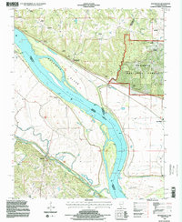
1994 Map of Rockwood
USGS Topo · Published 1996About this map
The Mississippi River creates a dynamic border between Illinois and Missouri on this mid-1990s survey, where the shifting river channel and extensive Levee systems define the low-lying bottomlands. Small agricultural settlements like Rockwood and Cora sit at the edge of the Shawnee National Forest, while the Missouri side features the community of Menfro along Cinque Hommes Creek. The landscape is notably dense with family and community burial grounds, including Tindall Cemetery, Kirk Cemetery, and Ebenezer Cemetery, providing a wealth of information for those researching the genealogy of Randolph and Jackson counties. Large river features such as Rockwood Island and Crains Island dominate the waterway, punctuated by navigational beacons and the secluded Point Rest. The map also captures the transition from the wooded uplands of the national forest to the engineered agricultural plains protected by embankments.
Find a feature on this map
40 named features on this map. Tap any name to fly to it.
Don’t see what you’re looking for? This feature index may not catch every label — zoom into the map to look around manually.
Map Details
Editions of this 1994 Rockwood Map
2 editions found

Other maps of this area

1915 · Chester
USGS Topo · 1:62,500

1916 · Campbell Hill
USGS Topo · 1:62,500

1918 · Altenburg
USGS Topo · 1:62,500

1918 · Campbell Hill
USGS Topo · 1:62,500

1923 · Perryville
USGS Topo · 1:62,500

1924 · Perryville
USGS Topo · 1:62,500

1925 · Altenburg
USGS Topo · 1:62,500

1947 · Chester
USGS Topo · 1:62,500

1947 · Crosstown
USGS Topo · 1:24,000

1947 · Altenburg
USGS Topo · 1:62,500