
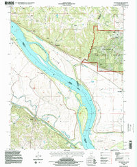
1994 Map of Rockwood
USGS Topo · Published 1996About this map
The Mississippi River dominates this mid-1990s landscape, serving as the volatile boundary between Illinois and Missouri. The river's influence is evident in the complex geography of Rockwood Island and Crains Island, as well as the numerous creeks like Bois Brule Creek and Cinque Hommes Creek that drain the floodplain. On the Illinois side, the riverbank is punctuated by the settlement of Rockwood, while the eastern hills rise into the Shawnee National Forest.
Find a feature on this map
35 named features on this map. Tap any name to fly to it.
Don’t see what you’re looking for? This feature index may not catch every label — zoom into the map to look around manually.
Map Details
Editions of this 1994 Rockwood Map
2 editions found
Other maps of this area

1915 · Chester
USGS Topo · 1:62,500

1916 · Campbell Hill
USGS Topo · 1:62,500

1918 · Altenburg
USGS Topo · 1:62,500

1918 · Campbell Hill
USGS Topo · 1:62,500

1923 · Perryville
USGS Topo · 1:62,500

1924 · Perryville
USGS Topo · 1:62,500

1925 · Altenburg
USGS Topo · 1:62,500

1947 · Chester
USGS Topo · 1:62,500

1947 · Crosstown
USGS Topo · 1:24,000

1947 · Altenburg
USGS Topo · 1:62,500