1930s Maps of Roblee, Missouri
Explore 2 historic maps of Roblee from the 1930s. These maps offer a rare glimpse into what life looked like during the 1930s — showing old roads, neighborhoods, homes, and landmarks that have changed or disappeared over time.
Whether you're researching your family's past, planning a metal detecting trip, or studying how Roblee's landscape evolved across the 1930s, these high-resolution maps are a powerful tool for exploring the history of this region.
- Focus on a specific era: All maps on this page are from the 1930s, giving you a focused view of this time period.
- See what’s changed: Compare century-old streets, trails, and buildings to today's modern landscape using overlays and satellite layers.
- Research with precision: Use these maps for genealogy, historical research, land use analysis, or educational projects.
- View, download, or print: Maps are fully viewable online in high resolution, and can be downloaded or printed for your own records.
Start exploring Roblee's history through authentic maps from the 1930s. This is your window into the past.
Roblee, MO maps
(2)- 1930 Map of Nebo
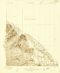
 1930 Nebo1930 Print · USGSThe Mississippi River bottomlands and Pike County bluffs are shown here in the late twenties, featuring a landscape of sloughs and rail-dependent towns. Trace family roots at Wildcat Cem or locate rural landmarks like Riprap Landing and Old Baptist Sch.
 - 1934 Map of Nebo
 1934 Nebo1934 Print · USGSThe Mississippi River borderlands in the mid-1930s reveal a landscape of river-and-rail commerce and high-ground settlements. Researchers can trace family history through the locations of Corinth Cem, the Greenwing Club, and rural schoolhouses like Farris Sch.4 unique versions available
End of results
Showing maps 1-2 of 2
Top cities near Roblee
- Pittsfield historical maps
- Louisiana historical maps
- Elsberry historical maps
- Pleasant Hill historical maps
- Atlas historical maps
- Clarksville historical maps
See more
Frequently asked questions
- What are the different types of historical maps available for Roblee?
- What is the oldest map of Roblee?
- Where can I purchase historical maps of Roblee for my home or office?
- Where can I download high-res historical maps of Roblee?
- Are there historical topographic maps available for Roblee?
- Is there historical aerial imagery available for Roblee?
- Where are historical maps of Roblee sourced from?