1950s Maps of Waynesville, Missouri
Explore 7 historic maps of Waynesville from the 1950s. These maps offer a rare glimpse into what life looked like during the 1950s — showing old roads, neighborhoods, homes, and landmarks that have changed or disappeared over time.
Whether you're researching your family's past, planning a metal detecting trip, or studying how Waynesville's landscape evolved across the 1950s, these high-resolution maps are a powerful tool for exploring the history of this region.
- Focus on a specific era: All maps on this page are from the 1950s, giving you a focused view of this time period.
- See what’s changed: Compare century-old streets, trails, and buildings to today's modern landscape using overlays and satellite layers.
- Research with precision: Use these maps for genealogy, historical research, land use analysis, or educational projects.
- View, download, or print: Maps are fully viewable online in high resolution, and can be downloaded or printed for your own records.
Start exploring Waynesville's history through authentic maps from the 1950s. This is your window into the past.
Waynesville, MO maps
(7)- 1954 Map of Springfield
 1954 Springfield1954 Print · USGSThe Missouri Ozarks are captured here during the post-war era, showing the expansion of Springfield and the surrounding river valleys. Genealogists and historians can trace local landmarks like Mount Comfort Cemetery and the Fort Leonard Wood military grounds.6 unique versions available
 - 1954 Map of Waynesville, 1958 Print
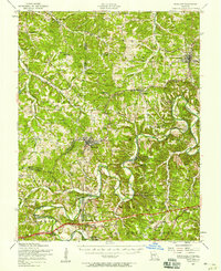
 1954 Waynesville1958 Print · USGSThe Missouri Ozarks are captured here during the mid-fifties, showing the expansion of Fort Leonard Wood and the winding course of the Gasconade River. Researchers can locate dozens of country landmarks, from the Dixon Lookout Tower to rural sites like Wheeler Mill and the Pisgah School.2 unique versions available
 - 1954 Map of Richland, 1958 Print
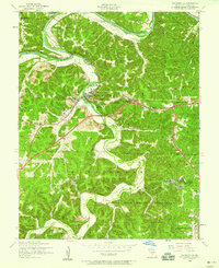
 1954 Richland1958 Print · USGSThe Gasconade River valley and the St. Louis-San Francisco rail line define this mid-Missouri landscape during the mid-fifties. Genealogists can trace family names through dozens of rural sites, including Thornsberry Cemetery, Makarie Bridge, and several early schoolhouses.2 unique versions available
 - 1954 Map of Waynesville, 1959 Print
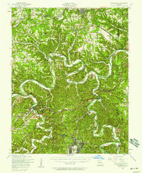
 1954 Waynesville1959 Print · USGSWaynesville and the surrounding Ozark hollows are captured in the mid-fifties as the local landscape adapted to the presence of the neighboring military reservation. Genealogists can trace family landmarks and rural institutions like Gospel Ridge Union Church, Storie Cem, and the Old Indian Lead Mine.5 unique versions available
 - 1954 Map of Ozark Springs, 1959 Print
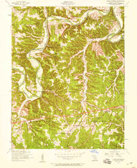 1954 Ozark Springs1959 Print · USGSPulaski County, Missouri, is shown here in the mid-1950s as a landscape of deep river bends and rural education nodes. Genealogists can trace family landmarks like Pauley Cem or locate several decommissioned sites such as Hickory Grove School.3 unique versions available
 - 1958 Map of Springfield
 1958 Springfield1958 Print · USGSThe Missouri Ozarks are captured during the mid-century era of growth, centered on the bustling hub of Springfield. Genealogists and historians can trace family roots through numerous landmarks like Ebenezer Church, Stockton Cem, and the various county courthouses.
 - 1959 Map of Springfield
 1959 Springfield1959 Print · USGSThe Missouri Ozarks are captured here during a decade of postwar growth and increasing highway connectivity. Researchers can trace the legacy of the St Louis-San Francisco RR and locate early sites in Springfield, Lebanon, and Mountain Grove.
End of results
Showing maps 1-7 of 7
Top cities near Waynesville
- Saint Robert historical maps
- Richland historical maps
- Dixon historical maps
- Crocker historical maps
- Powellville historical maps
Frequently asked questions
- What are the different types of historical maps available for Waynesville?
- What is the oldest map of Waynesville?
- Where can I purchase historical maps of Waynesville for my home or office?
- Where can I download high-res historical maps of Waynesville?
- Are there historical topographic maps available for Waynesville?
- Is there historical aerial imagery available for Waynesville?
- Where are historical maps of Waynesville sourced from?