1900s (20th Century) Maps of Pearl City, Missouri
Explore 7 historic maps of Pearl City from the 1900s (20th Century). These maps offer a rare glimpse into what life looked like during the 1900s — showing old roads, neighborhoods, homes, and landmarks that have changed or disappeared over time.
Whether you're researching your family's past, planning a metal detecting trip, or studying how Pearl City's landscape evolved across the 1900s, these high-resolution maps are a powerful tool for exploring the history of this region.
- Focus on a specific era: All maps on this page are from the 1900s, giving you a focused view of this time period.
- See what’s changed: Compare century-old streets, trails, and buildings to today's modern landscape using overlays and satellite layers.
- Research with precision: Use these maps for genealogy, historical research, land use analysis, or educational projects.
- View, download, or print: Maps are fully viewable online in high resolution, and can be downloaded or printed for your own records.
Start exploring Pearl City's history through authentic maps from the 1900s. This is your window into the past.
Pearl City, MO maps
(7)- 1939 Map of Centerville, 1954 Print
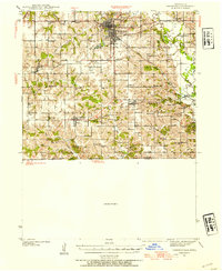 1939 Centerville1954 Print · USGSAppanoose County sits at a busy rail crossroads in the late thirties, just as the regional landscape was transitioning toward modern infrastructure. Genealogists can trace family footprints across dozens of rural landmarks like Cornbread College Sch, Jewish Cem, and Cincinnati.3 unique versions available
 - 1941 Map of Centerville
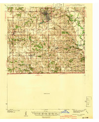 1941 Centerville1941 Print · USGSAppanoose County stands at a peak of rural development in the late thirties, where a dense network of railroads connects bustling border towns. Genealogists can trace family roots through numerous one-room schoolhouses like Cornbread College Sch and landmarks such as Livengod Cem.
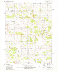
 - 1954 Map of Centerville, 1967 Print
 1954 Centerville1967 Print · USGSThe Iowa-Missouri borderlands at mid-century reveal a landscape shaped by river valleys and the height of the regional rail network. Genealogists and historians can trace the paths of the Wabash railroad and locate old townsites like Mystic, Moulton, and Greentop.3 unique versions available
 - 1957 Map of Centerville
 1957 Centerville1957 Print · USGSThe Iowa-Missouri borderlands in the mid-fifties reveal a landscape of river-valley agriculture and vital rail corridors. Genealogists and historians can trace family-named landmarks and small-town growth in Centerville, Kirksville, and along the Wabash railroad line.
 - 1958 Map of Centerville
 1958 Centerville1958 Print · USGSThe Iowa-Missouri borderlands come into focus during the mid-fifties, showing a landscape defined by river valleys and intersecting rail lines. Genealogists and local historians can trace family roots through dozens of rural hubs like Bloomfield, Unionville, and Corydon.
 - 1979 Map of Mendota, 1980 Print
 1979 Mendota1980 Print · USGSThe borderlands of Iowa and Missouri come to life in this late-seventies survey of Appanoose and Putnam counties. Genealogists and historians can trace the Old Railroad Grade and locate ancestral sites like Boswell Cemetery, Stringtown Church, and the village of Mendota.
 - 1981 Map of Centerville, 1982 Print
 1981 Centerville1982 Print · USGSThe borderlands of southern Iowa and northern Missouri are captured here in the early eighties as Rathbun Lake and the Chariton River define the local geography. Researchers can trace historic rail lines like the Norfolk and Western and locate vanished hamlets such as Coal City and Glenwood Junction.
End of results
Showing maps 1-7 of 7
Top cities near Pearl City
- Centerville historical maps
- Unionville historical maps
- Seymour historical maps
- Moulton historical maps
- Mystic historical maps
- Cincinnati historical maps
See more
Frequently asked questions
- What are the different types of historical maps available for Pearl City?
- What is the oldest map of Pearl City?
- Where can I purchase historical maps of Pearl City for my home or office?
- Where can I download high-res historical maps of Pearl City?
- Are there historical topographic maps available for Pearl City?
- Is there historical aerial imagery available for Pearl City?
- Where are historical maps of Pearl City sourced from?