1900s (20th Century) Maps of Flint Hill, Missouri
Explore 8 historic maps of Flint Hill from the 1900s (20th Century). These maps offer a rare glimpse into what life looked like during the 1900s — showing old roads, neighborhoods, homes, and landmarks that have changed or disappeared over time.
Whether you're researching your family's past, planning a metal detecting trip, or studying how Flint Hill's landscape evolved across the 1900s, these high-resolution maps are a powerful tool for exploring the history of this region.
- Focus on a specific era: All maps on this page are from the 1900s, giving you a focused view of this time period.
- See what’s changed: Compare century-old streets, trails, and buildings to today's modern landscape using overlays and satellite layers.
- Research with precision: Use these maps for genealogy, historical research, land use analysis, or educational projects.
- View, download, or print: Maps are fully viewable online in high resolution, and can be downloaded or printed for your own records.
Start exploring Flint Hill's history through authentic maps from the 1900s. This is your window into the past.
Flint Hill, MO maps
(8)- 1932 Map of Hannibal
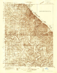
 1932 Hannibal1932 Print · USGSAlong the Mississippi River in the early 1930s, this survey captures the riverfront from Hannibal across to the Illinois bottomlands. Researchers can trace the river rail crossings of the WABASH and locate rural landmarks like Bird Slough Sch and the CHENALE ECARTE CLUB.4 unique versions available
 - 1936 Map of Hannibal
 1936 Hannibal1936 Print · USGSMid-century Hannibal and New London are shown during a transitional era of river commerce and early aviation. Researchers can trace the paths of the Burlington railroad or find ancestral landmarks like Withers Mill and Mt Olivet Cem.2 unique versions available
 - 1945 Map of Hannibal
 1945 Hannibal1945 Print · USGSMid-century Hannibal is captured here as a bustling Mississippi river port and railroad crossroads just after the war. Local historians can trace family roots through dozens of rural landmarks like Mt Zion Cem, Withers Mill, and Ocean Wave Sch.2 unique versions available
 - 1948 Map of Quincy
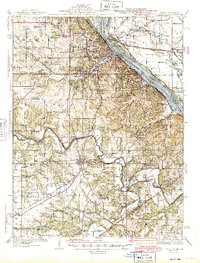
 1948 Quincy1948 Print · USGSThe Mississippi and Illinois River valleys are captured at a post-war crossroads as rail and river travel met the expanding highway system. Genealogists can trace family settlements from Quincy to Hannibal and smaller towns like Vandalia and Jerseyville.2 unique versions available
 - 1956 Map of Quincy, 1967 Print
 1956 Quincy1967 Print · USGSThe river and rail corridors of the Illinois-Missouri border are documented here during the mid-1950s. Researchers can trace historic river landings and regional transit hubs from Quincy and Hannibal to smaller settlements like Meredosia and Roodhouse.3 unique versions available
 - 1971 Map of New London, 1973 Print
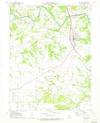 1971 New London1973 Print · USGSNew London and the surrounding Ralls County countryside are captured in the early seventies, showcasing a landscape of river-bend farms and rural parishes. Researchers can locate numerous family cemeteries such as Barkley Cem or trace the path of the Old Railroad Grade.
 - 1986 Map of Quincy
 1986 Quincy1986 Print · USGSThe tri-state border region along the Mississippi River comes into focus during the mid-1980s. Researchers can trace the legacy of river towns and rail hubs like Quincy and Monroe City or locate landmarks such as Mount Olive Cem.2 unique versions available
 - 1991 Map of New London, 1995 Print
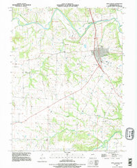 1991 New London1995 Print · USGSNew London and the Ralls County countryside are captured here in the early nineties, centered on the Salt River valley. Genealogists and local historians can trace numerous rural burial sites including Barkley Cem, Flowerree Cem, and Mt Sterling Cem.
End of results
Showing maps 1-8 of 8
Top cities near Flint Hill
- Hannibal historical maps
- Palmyra historical maps
- Payson historical maps
- New London historical maps
- Fall Creek historical maps
- Center historical maps
See more
Frequently asked questions
- What are the different types of historical maps available for Flint Hill?
- What is the oldest map of Flint Hill?
- Where can I purchase historical maps of Flint Hill for my home or office?
- Where can I download high-res historical maps of Flint Hill?
- Are there historical topographic maps available for Flint Hill?
- Is there historical aerial imagery available for Flint Hill?
- Where are historical maps of Flint Hill sourced from?