1900s (20th Century) Maps of Doniphan, Missouri
Explore 9 historic maps of Doniphan from the 1900s (20th Century). These maps offer a rare glimpse into what life looked like during the 1900s — showing old roads, neighborhoods, homes, and landmarks that have changed or disappeared over time.
Whether you're researching your family's past, planning a metal detecting trip, or studying how Doniphan's landscape evolved across the 1900s, these high-resolution maps are a powerful tool for exploring the history of this region.
- Focus on a specific era: All maps on this page are from the 1900s, giving you a focused view of this time period.
- See what’s changed: Compare century-old streets, trails, and buildings to today's modern landscape using overlays and satellite layers.
- Research with precision: Use these maps for genealogy, historical research, land use analysis, or educational projects.
- View, download, or print: Maps are fully viewable online in high resolution, and can be downloaded or printed for your own records.
Start exploring Doniphan's history through authentic maps from the 1900s. This is your window into the past.
Doniphan, MO maps
(9)- 1939 Map of Doniphan, 1958 Print
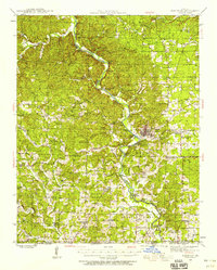 1939 Doniphan1958 Print · USGSRipley County is captured in the late 1930s as a landscape of river-bend settlements and numerous rural schoolhouses. Genealogists can locate family landmarks like Ponder, Poynor, and several country churches including New Home Ch.3 unique versions available
 - 1945 Map of Doniphan
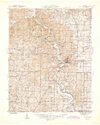 1945 Doniphan1945 Print · USGSThe Current River valley and the railroad terminus at Doniphan are shown in the mid-1940s just as the region's river-camp culture was thriving. Genealogists can locate family names at Mill Creek Sch, Kennon Cem, and the settlement of Poynor.2 unique versions available
 - 1957 Map of Poplar Bluff, 1968 Print
 1957 Poplar Bluff1968 Print · USGSThe Missouri-Arkansas border region is captured here as the timber and rail industries shaped the Ozark foothills. Genealogists and historians can trace the Missouri Pacific Railroad through river towns like Pocahontas, Greenville, and Van Buren.3 unique versions available
 - 1959 Map of Poplar Bluff
 1959 Poplar Bluff1959 Print · USGSThe Missouri Ozarks and Arkansas borderlands meet in this late 1950s study of the region's diverse terrain and rail-fed towns. Researchers can trace the path of the Missouri Pacific Railroad through Poplar Bluff or locate smaller settlements like Birch Tree and Myrtle.
 - 1960 Map of Poplar Bluff
 1960 Poplar Bluff1960 Print · USGSSoutheast Missouri and Northeast Arkansas are captured here during the post-war era, showing the transition from the Ozark highlands to the Delta. Genealogists and historians can trace rail corridors like the St. Louis Southwestern RR and remote settlements such as Birch Tree and Warm Springs.
 - 1980 Map of Doniphan North
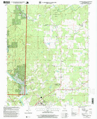
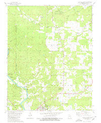 1980 Doniphan North1980 Print · USGSRipley County in the early eighties shows a landscape defined by state and national forests and the winding Current River. Researchers can locate many family landmarks, from Brooks Cem and Lone Star Sch to the Rancho Rio Landing Strip.
 - 1980 Map of Doniphan South
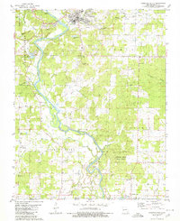 1980 Doniphan South1980 Print · USGSRipley County is captured here at the start of the 1980s, where the winding Current River meets the Arkansas border. Researchers can locate family landmarks such as Pope Chapel Cem, Gartman Cem, and the rural community of Current View.
 - 1983 Map of Poplar Bluff
 1983 Poplar Bluff1983 Print · USGSSoutheast Missouri in the early 1980s reveals a landscape defined by the Ozark foothills and the complex drainage systems of the Bootheel. Researchers can trace the rail corridors of the Missouri Pacific RR through Poplar Bluff or locate rural sites like Wilhelmina Church and Lone Hill Lookout.
 - 1997 Map of Doniphan North, 1999 Print
 1997 Doniphan North1999 Print · USGSRipley County in the late 1990s was a landscape where the Current River met the deep woods of the Mark Twain National Forest. Local historians can trace family locations near the Mc Gee-Payne Cemetery, the old Fairview School, or the Doniphan Lookout.
End of results
Showing maps 1-9 of 9
Top cities near Doniphan
- Corning historical maps
- Naylor historical maps
- Maynard historical maps
- Grandin historical maps
- Success historical maps
Top neighborhoods of Doniphan
Frequently asked questions
- What are the different types of historical maps available for Doniphan?
- What is the oldest map of Doniphan?
- Where can I purchase historical maps of Doniphan for my home or office?
- Where can I download high-res historical maps of Doniphan?
- Are there historical topographic maps available for Doniphan?
- Is there historical aerial imagery available for Doniphan?
- Where are historical maps of Doniphan sourced from?