1960s Maps of Schuyler County, Missouri
Explore 4 historic maps of Schuyler County from the 1960s. These maps offer a rare glimpse into what life looked like during the 1960s — showing old roads, neighborhoods, homes, and landmarks that have changed or disappeared over time.
Whether you're researching your family's past, planning a metal detecting trip, or studying how Schuyler County's landscape evolved across the 1960s, these high-resolution maps are a powerful tool for exploring the history of this region.
- Focus on a specific era: All maps on this page are from the 1960s, giving you a focused view of this time period.
- See what’s changed: Compare century-old streets, trails, and buildings to today's modern landscape using overlays and satellite layers.
- Research with precision: Use these maps for genealogy, historical research, land use analysis, or educational projects.
- View, download, or print: Maps are fully viewable online in high resolution, and can be downloaded or printed for your own records.
Start exploring Schuyler County's history through authentic maps from the 1960s. This is your window into the past.
Schuyler County, MO maps
(4)- 1965 Map of Downing NW, 1967 Print
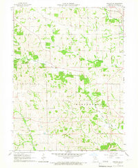 1965 Downing NW1967 Print · USGSSchuyler County's agricultural heartland is documented here in the mid-1960s, showing a landscape shaped by the Fabius River and local rail lines. Researchers can trace family ties at sites like Germania Ch, Crowder Cem, and along the Chicago Burlington and Quincy railroad.
 - 1966 Map of Downing, 1967 Print
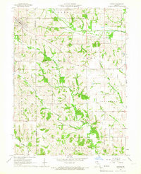 1966 Downing1967 Print · USGSSchuyler and Scotland counties appear here in the mid-1960s, showing a rural landscape defined by the North Fabius River and the local rail line. Researchers can locate family landmarks like Friendship Cem, Middle Fabius Sch, and the community of Downing.
 - 1966 Map of Bible Grove, 1967 Print
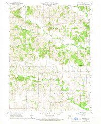 1966 Bible Grove1967 Print · USGSNortheast Missouri farm country is captured here in the mid-sixties at the junction of Scotland, Adair, and Knox Counties. Genealogists and local historians can trace the rural landscape around Bible Grove, Adair, and the Pleasant Ridge Ch.
 - 1966 Map of Willmathsville, 1967 Print
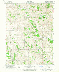 1966 Willmathsville1967 Print · USGSThe rural borders of Adair and Schuyler Counties come to life in the mid-1960s, showing a landscape shaped by the Salt River and its many forks. Researchers can trace family roots at Bethel Ch Cem and Richardson Cem or explore the quiet crossroads of Sperry and Willmathsville.
End of results
Showing maps 1-4 of 4
Top cities of Schuyler County
Frequently asked questions
- What are the different types of historical maps available for Schuyler County?
- What is the oldest map of Schuyler County?
- Where can I purchase historical maps of Schuyler County for my home or office?
- Where can I download high-res historical maps of Schuyler County?
- Are there historical topographic maps available for Schuyler County?
- Is there historical aerial imagery available for Schuyler County?
- Where are historical maps of Schuyler County sourced from?