1950s Maps of Scotland County, Missouri
Explore 7 historic maps of Scotland County from the 1950s. These maps offer a rare glimpse into what life looked like during the 1950s — showing old roads, neighborhoods, homes, and landmarks that have changed or disappeared over time.
Whether you're researching your family's past, planning a metal detecting trip, or studying how Scotland County's landscape evolved across the 1950s, these high-resolution maps are a powerful tool for exploring the history of this region.
- Focus on a specific era: All maps on this page are from the 1950s, giving you a focused view of this time period.
- See what’s changed: Compare century-old streets, trails, and buildings to today's modern landscape using overlays and satellite layers.
- Research with precision: Use these maps for genealogy, historical research, land use analysis, or educational projects.
- View, download, or print: Maps are fully viewable online in high resolution, and can be downloaded or printed for your own records.
Start exploring Scotland County's history through authentic maps from the 1950s. This is your window into the past.
Scotland County, MO maps
(7)- 1950 Map of Colony, 1976 Print
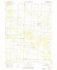 1950 Colony1976 Print · USGSNortheast Missouri at the mid-century mark reveals a rural landscape defined by independent school districts and quiet creek valleys. Genealogists and historians can trace the foundations of local life at Sutter Cem, Fairmont, and the Arkansas Sch.
 - 1951 Map of Colony
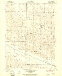 1951 Colony1951 Print · USGSNortheast Missouri agriculture and small-town life are captured here at mid-century, where the four corners of Clark, Scotland, Knox, and Lewis counties converge. Researchers can trace family roots through sites like Sutter Cem, Bear Creek Ch, and schools such as Price Sch.2 unique versions available
 - 1951 Map of Wyaconda
 1951 Wyaconda1951 Print · USGSNortheast Missouri’s rural character is captured here during the early fifties as railroads and river channels shaped the landscape. Genealogists can locate family-named sites and landmarks like Etna Cem, Flint Ridge Sch, and the rail junction at Wyaconda.2 unique versions available
 - 1954 Map of Centerville, 1967 Print
 1954 Centerville1967 Print · USGSThe Iowa-Missouri borderlands at mid-century reveal a landscape shaped by river valleys and the height of the regional rail network. Genealogists and historians can trace the paths of the Wabash railroad and locate old townsites like Mystic, Moulton, and Greentop.3 unique versions available
 - 1957 Map of Centerville
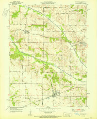
 1957 Centerville1957 Print · USGSThe Iowa-Missouri borderlands in the mid-fifties reveal a landscape of river-valley agriculture and vital rail corridors. Genealogists and historians can trace family-named landmarks and small-town growth in Centerville, Kirksville, and along the Wabash railroad line.
 - 1958 Map of Centerville
 1958 Centerville1958 Print · USGSThe Iowa-Missouri borderlands come into focus during the mid-fifties, showing a landscape defined by river valleys and intersecting rail lines. Genealogists and local historians can trace family roots through dozens of rural hubs like Bloomfield, Unionville, and Corydon.
 - 1958 Map of Burlington, 1968 Print
 1958 Burlington1968 Print · USGSThe tri-state river country of Iowa, Illinois, and Missouri is captured here in the mid-fifties, dominated by the Mississippi River and major rail lines. Genealogists and historians can trace the development of river towns like Keokuk or locate the sprawling Iowa Army Ammunition Plant.4 unique versions available
End of results
Showing maps 1-7 of 7
Top cities of Scotland County
- Memphis historical maps
- Rutledge historical maps
- South Gorin historical maps
- Dancing Rabbit Ecovillage historical maps
- Granger historical maps
- Arbela historical maps
Frequently asked questions
- What are the different types of historical maps available for Scotland County?
- What is the oldest map of Scotland County?
- Where can I purchase historical maps of Scotland County for my home or office?
- Where can I download high-res historical maps of Scotland County?
- Are there historical topographic maps available for Scotland County?
- Is there historical aerial imagery available for Scotland County?
- Where are historical maps of Scotland County sourced from?