
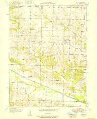
1951 Map of Colony
USGS Topo · Published 1951About this map
The North Fabius River and its meandering Old Channel define the lower third of this Missouri landscape, where the borders of Clark, Scotland, Knox, and Lewis counties meet. In the early 1950s, the rural community of Colony sits near the southern edge, while Fairmont serves as a northern hub at the crossroads of local thoroughfares. The terrain is deeply carved by drainage systems like Bear Creek and Shaffer Creek, which separate the upland farmsteads.
Find a feature on this map
25 named features on this map. Tap any name to fly to it.
Don’t see what you’re looking for? This feature index may not catch every label — zoom into the map to look around manually.
Map Details
Editions of this 1951 Colony Map
2 editions found
Other maps of this area

1903 · Kahoka
USGS Topo · 1:125,000

1903 · Edina
USGS Topo · 1:125,000

1950 · Neeper
USGS Topo · 1:24,000

1950 · Williamstown
USGS Topo · 1:24,000

1950 · Medill
USGS Topo · 1:24,000

1950 · Colony
USGS Topo · 1:24,000

1951 · Neeper
USGS Topo · 1:24,000

1951 · Medill
USGS Topo · 1:24,000
1951 · Williamstown
USGS Topo · 1:24,000

1951 · Wyaconda
USGS Topo · 1:24,000