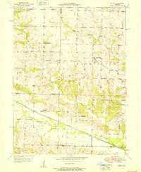
1951 Map of Colony
USGS Topo · Published 1951About this map
The North Fabius River and its meandering Old Channel define the southern landscape of this 1951 survey, where the boundaries of Clark, Scotland, Knox, and Lewis counties converge. The terrain is characterized by a dense network of rural infrastructure, from the village of Fairmont in Washington township to the eponymous settlement of Colony further south. This era of rural education transition is clearly visible, with several institutions already marked as inactive, including Arkansas Sch and Davis Sch. For genealogists, the map preserves the locations of family-named burial grounds like Sutter Cem and Standiford Cem. The hydrology is equally detailed, featuring the Little Wyaconda River and numerous tributaries such as Shaffer Creek and Vernon Branch, which carved the undulating landscape prior to modern development.
Find a feature on this map
25 named features on this map. Tap any name to fly to it.
Don’t see what you’re looking for? This feature index may not catch every label — zoom into the map to look around manually.
Map Details
Editions of this 1951 Colony Map
2 editions found
Other maps of this area

1903 · Kahoka
USGS Topo · 1:125,000

1903 · Edina
USGS Topo · 1:125,000

1950 · Neeper
USGS Topo · 1:24,000

1950 · Williamstown
USGS Topo · 1:24,000

1950 · Medill
USGS Topo · 1:24,000

1950 · Colony
USGS Topo · 1:24,000

1951 · Colony
USGS Topo · 1:24,000

1951 · Neeper
USGS Topo · 1:24,000

1951 · Medill
USGS Topo · 1:24,000
1951 · Williamstown
USGS Topo · 1:24,000