1960s Maps of Scotland County, Missouri
Explore 9 historic maps of Scotland County from the 1960s. These maps offer a rare glimpse into what life looked like during the 1960s — showing old roads, neighborhoods, homes, and landmarks that have changed or disappeared over time.
Whether you're researching your family's past, planning a metal detecting trip, or studying how Scotland County's landscape evolved across the 1960s, these high-resolution maps are a powerful tool for exploring the history of this region.
- Focus on a specific era: All maps on this page are from the 1960s, giving you a focused view of this time period.
- See what’s changed: Compare century-old streets, trails, and buildings to today's modern landscape using overlays and satellite layers.
- Research with precision: Use these maps for genealogy, historical research, land use analysis, or educational projects.
- View, download, or print: Maps are fully viewable online in high resolution, and can be downloaded or printed for your own records.
Start exploring Scotland County's history through authentic maps from the 1960s. This is your window into the past.
Scotland County, MO maps
(9)- 1961 Map of Burlington
 1961 Burlington1961 Print · USGSThe tri-state borderlands along the Mississippi River are captured here during the late fifties and early sixties, showing the vital river-and-rail economy of Iowa, Illinois, and Missouri. Genealogists and historians can trace the development of major hubs like Galesburg and Macomb alongside landmark sites such as the Iowa Ordnance Plant and the historic river town of Nauvoo.
 - 1963 Map of Burlington
 1963 Burlington1963 Print · USGSThe tri-state river country of the Mississippi and Illinois valleys comes alive in this mid-century survey. Genealogists and historians can trace the industrial and academic growth of the region, from the Iowa Ordnance Plant to campuses like Knox College and Western Illinois University.
 - 1965 Map of Memphis, 1966 Print
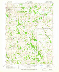
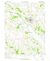 1965 Memphis1966 Print · USGSMemphis was a central rail and agricultural hub in Scotland County during the mid-sixties. Genealogists and historians can trace several rural landmarks including Oakridge Ch, McAdow Ch, and family sites like Clark Cem or the Memphis-Schenck Airstrip.2 unique versions available
 - 1965 Map of Rutledge, 1966 Print
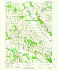 1965 Rutledge1966 Print · USGSScotland and Knox Counties are captured here in the mid-1960s, showing a landscape defined by the Fabius River and the railroad. Genealogists and local historians can trace rural roots at Pauline Cem, Gorin, and the small settlement of Millport.
 - 1965 Map of Arbela, 1966 Print
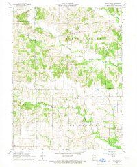
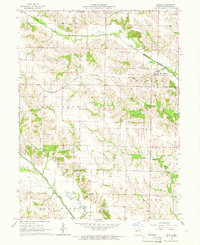 1965 Arbela1966 Print · USGSScotland County in the mid-1960s shows a landscape still centered on the rail line and a network of rural townships. Genealogists and local historians can trace family locations through several burial grounds and community sites, including Union Cem, Hickory Grove Ch, and Buskirk Cem.
 - 1965 Map of Greensburg, 1966 Print
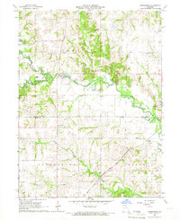 1965 Greensburg1966 Print · USGSScotland County farming communities are captured here in the mid-sixties at a time when family homesteads and rural cemeteries still defined the landscape. Genealogists can locate pioneer burial sites like Fort Donaldson Cem and Frogge Cem or trace the route of the Atchison Topeka and Santa Fe railroad.
 - 1966 Map of Downing, 1967 Print
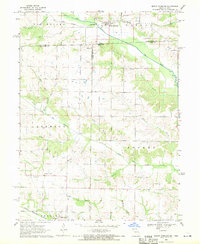
 1966 Downing1967 Print · USGSSchuyler and Scotland counties appear here in the mid-1960s, showing a rural landscape defined by the North Fabius River and the local rail line. Researchers can locate family landmarks like Friendship Cem, Middle Fabius Sch, and the community of Downing.
 - 1966 Map of Bible Grove, 1967 Print
 1966 Bible Grove1967 Print · USGSNortheast Missouri farm country is captured here in the mid-sixties at the junction of Scotland, Adair, and Knox Counties. Genealogists and local historians can trace the rural landscape around Bible Grove, Adair, and the Pleasant Ridge Ch.
 - 1968 Map of Mount Sterling, 1970 Print
 1968 Mount Sterling1970 Print · USGSCrossing the Iowa-Missouri border in the late sixties, this survey captures the rural landscape between Mount Sterling and Prospect Grove. Genealogists can trace family roots at Harness Cem, Blackledge Cem, and Asbury Ch along the Fox River valley.3 unique versions available
End of results
Showing maps 1-9 of 9
Top cities of Scotland County
- Memphis historical maps
- Rutledge historical maps
- South Gorin historical maps
- Dancing Rabbit Ecovillage historical maps
- Granger historical maps
- Arbela historical maps
Frequently asked questions
- What are the different types of historical maps available for Scotland County?
- What is the oldest map of Scotland County?
- Where can I purchase historical maps of Scotland County for my home or office?
- Where can I download high-res historical maps of Scotland County?
- Are there historical topographic maps available for Scotland County?
- Is there historical aerial imagery available for Scotland County?
- Where are historical maps of Scotland County sourced from?