Old Maps of Scott County, Missouri for Hiking & Exploration
Hike through history with 120 historic maps of Scott County. Explore old trails, ghost towns, and forgotten backroads — perfect for outdoor adventurers and local explorers.
- Rediscover forgotten places: Map out old mining camps, roads, and footpaths that no longer exist on modern maps.
- Layer with modern tools: Combine with LiDAR or satellite views to plan hikes through historical terrain.
- Made for exploration: Popular among hikers, overlanders, and local history lovers.
Use these maps to find adventure and explore the hidden past of Scott County.
Scott County, MO maps
(120)- 1920 Map of Jonesboro
 1920 Jonesboro1920 Print · USGSSouthern Illinois during the late post-war era reveals a complex landscape of Mississippi riverfront bottoms and high ridges. Genealogists can trace family roots through numerous local landmarks, from the Casper Church to rural schools like Big Barn School and McClure School.
 - 1923 Map of Jonesboro
 1923 Jonesboro1923 Print · USGSThe Mississippi River bottoms and Shawnee hills meet in the early 1920s, showing a landscape of rail-dependent towns and rural schools. Trace family roots at Casper Church, follow the Mobile and Ohio Railroad, or locate Moccasin Springs.2 unique versions available
 - 1931 Map of Sikeston
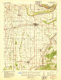
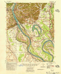
 1931 Sikeston1931 Print · USGSSikeston and the surrounding Bootheel lowlands are captured here in the early 1930s as a massive drainage network transformed the landscape into fertile farmland. Researchers can trace the development of small rail towns like Morehouse and Canalou alongside old country schools like Stringer Sch and Hale Sch.2 unique versions available
 - 1934 Map of Thebes
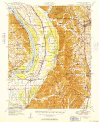
 1934 Thebes1934 Print · USGSThe Mississippi River corridor south of Thebes shows a landscape of rail junctions and bottomland farming in the 1930s. Genealogists can locate family landmarks like Pollard Cemetery, Mt Zion Ch, and schools such as Ownsby Sch or Lemon Sch.4 unique versions available
 - 1934 Map of Morley
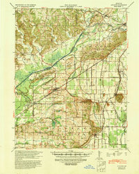
 1934 Morley1934 Print · USGSSoutheastern Missouri during the 1930s reveals a landscape being reshaped by massive drainage projects. Genealogists can trace family roots at Hunter Sch or locate ancestors in settlements like Morley, Benton, and the rail junction at Brooks Junction.3 unique versions available
 - 1934 Map of Sikeston
 1934 Sikeston1934 Print · USGSSikeston and the surrounding Scott County lowlands are captured here in the 1930s as a thriving rail and drainage network. Genealogists can trace family roots through dozens of rural sites like Carpenter Cem, Silent Hill Ch, and the Warner Sch.2 unique versions available
 - 1934 Map of Advance
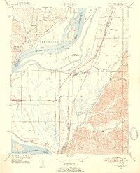
 1934 Advance1934 Print · USGSSoutheast Missouri in the 1930s is mapped here during a period of major hydrological change and railroad activity. You can trace the Diversion Channel across the landscape or find rural schools and family burial sites like Toga No 2 Sch and St Joseph Cem.3 unique versions available
 - 1939 Map of Sikeston
 1939 Sikeston1939 Print · USGSIn the 1930s, the Missouri Bootheel was a landscape defined by industrial-scale drainage and a dense rail network. Trace the legacy of rural education and faith at Silent Hill Ch, Landers Ridge Sch, and the community of Morehouse.
 - 1939 Map of Charleston, 1941 Print
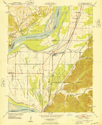
 1939 Charleston1941 Print · USGSThe Missouri Bootheel near Charleston is shown here just as the modern levee and ditch systems were taking final shape. Researchers can trace the era's rural social fabric through numerous local landmarks like Pulltight Sch, Maynard Cem, and the St Louis Southwestern rail line.2 unique versions available
 - 1939 Map of Morley, 1942 Print
 1939 Morley1942 Print · USGSSoutheast Missouri was undergoing a massive hydrological transformation in the late 1930s as engineers redirected the Whitewater River. Genealogists and historians can trace rail-depot towns like Chaffee and Morley alongside vanished rural landmarks like Bryan Sch and Brooks Junction.2 unique versions available
 - 1939 Map of Advance, 1942 Print
 1939 Advance1942 Print · USGSSoutheast Missouri in the late thirties is defined here by its massive drainage projects and thriving rail towns. Researchers can trace the heritage of rural communities through dozens of local landmarks like Cruse Cem, Dongola Sch, and Union Grove Ch.
 - 1939 Map of Thebes, 1946 Print
 1939 Thebes1946 Print · USGSSouthern Illinois and the Mississippi River bottomlands are captured here just before the 1940s, showing a landscape defined by rail junctions and river islands. Genealogists can locate family landmarks like Pollard Cemetery, Unity Ch, and several rural schoolhouses including Powers Island Sch.
 - 1947 Map of Jonesboro, 1954 Print
 1947 Jonesboro1954 Print · USGSSouthern Illinois in the late 1940s reveals a landscape defined by the Mississippi riverfront and the deep woods of the Shawnee National Forest. Researchers can trace early rural infrastructure through numerous sites like Egypt Mills, Dutch Mills, and the historic Kornthal Church.3 unique versions available
 - 1947 Map of Mc Clure, 1954 Print
 1947 Mc Clure1954 Print · USGSThe Illinois-Missouri borderlands along the Mississippi River come to life in the late 1940s, showing a landscape defined by flood control and rail transport. Trace local history through the Illinois Central Railroad and landmarks like McClure or Hobbs Chapel.3 unique versions available
 - 1948 Map of McClure
 1948 McClure1948 Print · USGSThe Mississippi River bottomlands at the Illinois-Missouri border are captured here just after the war. Local researchers can trace family landmarks like Lindsey Cem or old schoolhouses such as Reynoldsville Sch and East Cape Girardeau School.
 - 1949 Map of Jonesboro
 1949 Jonesboro1949 Print · USGSSouthern Illinois and eastern Missouri meet along the river in the late 1940s, showing a landscape of fertile bottomlands and timbered ridges. Genealogists can locate family landmarks like Kornthal Church, Tripp Cem, and the Misenheimer School.
 - 1949 Map of Paducah
 1949 Paducah1949 Print · USGSThe confluence of the Ohio, Mississippi, Tennessee, and Cumberland rivers at the close of the 1940s reveals a region bound by water and rail. Researchers can trace historic river landings, timberlands in the Shawnee National Forest, and the coal-mining infrastructure around West Frankfort and Herrin.2 unique versions available
 - 1950 Map of Paducah
 1950 Paducah1950 Print · USGSThe confluence of the great midwestern rivers defines this mid-century landscape at the intersection of Illinois, Kentucky, and Missouri. Genealogists and historians can trace the rail-and-river economy through the hubs of Paducah, Cairo, and Metropolis or locate family roots near the Wildcat Hills.
 - 1954 Map of Charleston
 1954 Charleston1954 Print · USGSSoutheastern Missouri's river country is captured here during the mid-1950s, showing the complex drainage systems of the Bootheel. Researchers can locate dozens of rural landmarks like Bridges Ch & Sch, Maynard Cem, and the Missouri Pacific line.2 unique versions available
 - 1954 Map of Paducah
 1954 Paducah1954 Print · USGSSouthern Illinois and Western Kentucky intersect at the great river confluences during this mid-century era of rail and river industry. Genealogists and historians can trace family roots and commerce through river towns like Cairo, Metropolis, and Golconda, or along the tracks of the Illinois Central Railroad.2 unique versions available
 - 1955 Map of Thebes
 1955 Thebes1955 Print · USGSThe Illinois riverfront near the confluence of the Mississippi and Cache rivers shows a landscape of timber and rail in the mid-1950s. Genealogists and historians can trace family locations near Richwood Cem, the junction at Thebes, and remote rural schoolhouses like Owensby Sch.
 - 1956 Map of Dyersburg, 1960 Print
 1956 Dyersburg1960 Print · USGSThe Four Rivers region comes alive in the mid-fifties, capturing the intricate borderlands of Tennessee, Kentucky, and Missouri. Genealogists and historians can trace the rail-and-river networks connecting Dyersburg, Caruthersville, and the shoreline of Reelfoot Lake.4 unique versions available
 - 1961 Map of Paducah
 1961 Paducah1961 Print · USGSThe Lower Ohio Valley at mid-century is a landscape defined by its great rivers and newly formed reservoirs. Researchers can trace the riverfronts of Paducah and Metropolis, or locate smaller settlements like Old Shawneetown and Cave in Rock along the banks.2 unique versions available
 - 1963 Map of Sikeston North, 1964 Print
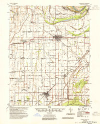
 1963 Sikeston North1964 Print · USGSSikeston was a growing hub of the Missouri bootheel in the early 1960s, centered at the crossing of major rail lines. Family historians can trace numerous rural burial grounds like Hunter Cem and Gobb Cem, or find local landmarks like the Drive-in Theater.2 unique versions available
 - 1963 Map of Scott City, 1964 Print
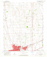
 1963 Scott City1964 Print · USGSSoutheastern Missouri at the start of the 1960s shows a landscape of engineered drainage and rail-side growth. Trace local history through the streets of Scott City and Ilmo, or find family roots at Ancell Cem and Spradlin Cem.2 unique versions available
Showing maps 1-25 of 120
Top cities of Scott County
- Sikeston historical maps
- Scott City historical maps
- Chaffee historical maps
- Oran historical maps
- Morley historical maps
- Benton historical maps
See more
Frequently asked questions
- What are the different types of historical maps available for Scott County?
- What is the oldest map of Scott County?
- Where can I purchase historical maps of Scott County for my home or office?
- Where can I download high-res historical maps of Scott County?
- Are there historical topographic maps available for Scott County?
- Is there historical aerial imagery available for Scott County?
- Where are historical maps of Scott County sourced from?