
1920 Map of Jonesboro
USGS Topo · Published 1920About this map
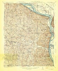
Jonesboro and the neighboring community of Anna serve as the primary hubs in this southern Illinois landscape, situated at the junction of the Illinois Central and Mobile and Ohio Road rail corridors. The terrain transitions sharply from the rugged elevations of Atwood Ridge and Hamburg Hill down to the fertile bottomlands of the Mississippi River. Along this western edge, the river defines a complex geography of secondary channels and islands, such as Devils Island.
Find a feature on this map
73 named features on this map. Tap any name to fly to it.
Don’t see what you’re looking for? This feature index may not catch every label — zoom into the map to look around manually.
Map Details
Editions of this 1920 Jonesboro Map
This is the sole edition of this map. No revisions or reprints were ever made.
Other maps of this area

1918 · Altenburg
USGS Topo · 1:62,500

1920 · Dongola
USGS Topo · 1:62,500

1922 · Carbondale
USGS Topo · 1:62,500

1922 · Cape Girardeau
USGS Topo · 1:62,500

1923 · Dongola
USGS Topo · 1:62,500

1923 · Jonesboro
USGS Topo · 1:62,500

1924 · Cape Girardeau
USGS Topo · 1:62,500

1924 · Alto Pass
USGS Topo · 1:62,500
1925 · Altenburg
USGS Topo · 1:62,500

1931 · Cairo
USGS Topo · 1:62,500