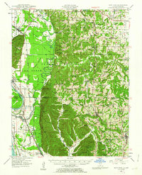
1924 Map of Alto Pass
USGS Topo · Published 1924About this map
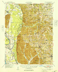
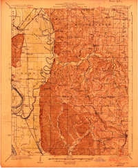
Mississippi River crossings and rugged southern Illinois terrain define this 1920s survey, which highlights a landscape of ridges and bottomlands before modern highway expansion. The eastern portion is anchored by Alto Pass and Cobden, while the western floodplains feature extensive engineering including the Hay Glade Ditch and a network of schools serving rural families, such as Macedonia School and Hickory Ridge School. Transport in this era relied heavily on the Illinois Central and Missouri Pacific railroads, alongside river access points like Rattlesnake Ferry and Kings Ferry. The map documents a high density of country churches, including Dutch Ridge Church and Union Springs Church, which acted as centers for these small agricultural communities. Notable natural landmarks like Fountain Bluff and Grassy Knob rise above the winding Muddy River, illustrating the complex topography that shaped settlement patterns in Jackson and Union counties.
Find a feature on this map
101 named features on this map. Tap any name to fly to it.
Don’t see what you’re looking for? This feature index may not catch every label — zoom into the map to look around manually.
Map Details
Editions of this 1924 Alto Pass Map
2 editions found
Historical Maps of Carbondale Through Time
3 maps found