
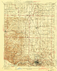
1910 Map of Murphysboro
USGS Topo · Published 1910About this map
The Muddy River defines the southern reach of this Illinois landscape, winding past the industrial and rail hub of Murphysboro. This 1908 survey illustrates a region defined by its dense network of rural infrastructure, where small settlements like Vergennes and Ava are connected by an intricate web of competing rail lines, including the Illinois Central and the Mobile and Ohio. The concentration of one-room schoolhouses such as Sodom School, Sugar Hill School, and Jenkins School reflects the agrarian social structure of Jackson and Perry counties before the consolidation of rural districts.
Find a feature on this map
82 named features on this map. Tap any name to fly to it.
Don’t see what you’re looking for? This feature index may not catch every label — zoom into the map to look around manually.
Map Details
Editions of this 1910 Murphysboro Map
2 editions found
Other maps of this area

1910 · Herrin
USGS Topo · 1:62,500

1914 · Coulterville
USGS Topo · 1:62,500

1916 · Campbell Hill
USGS Topo · 1:62,500

1917 · Coulterville
USGS Topo · 1:62,500

1918 · Altenburg
USGS Topo · 1:62,500

1918 · Campbell Hill
USGS Topo · 1:62,500

1922 · Carbondale
USGS Topo · 1:62,500

1924 · Alto Pass
USGS Topo · 1:62,500

1924 · Pinckneyville
USGS Topo · 1:62,500

1925 · Altenburg
USGS Topo · 1:62,500