1960s Maps of Sikeston, Missouri
Explore 4 historic maps of Sikeston from the 1960s. These maps offer a rare glimpse into what life looked like during the 1960s — showing old roads, neighborhoods, homes, and landmarks that have changed or disappeared over time.
Whether you're researching your family's past, planning a metal detecting trip, or studying how Sikeston's landscape evolved across the 1960s, these high-resolution maps are a powerful tool for exploring the history of this region.
- Focus on a specific era: All maps on this page are from the 1960s, giving you a focused view of this time period.
- See what’s changed: Compare century-old streets, trails, and buildings to today's modern landscape using overlays and satellite layers.
- Research with precision: Use these maps for genealogy, historical research, land use analysis, or educational projects.
- View, download, or print: Maps are fully viewable online in high resolution, and can be downloaded or printed for your own records.
Start exploring Sikeston's history through authentic maps from the 1960s. This is your window into the past.
Sikeston, MO maps
(4)- 1963 Map of Sikeston North, 1964 Print
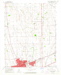 1963 Sikeston North1964 Print · USGSSikeston was a growing hub of the Missouri bootheel in the early 1960s, centered at the crossing of major rail lines. Family historians can trace numerous rural burial grounds like Hunter Cem and Gobb Cem, or find local landmarks like the Drive-in Theater.2 unique versions available
 - 1963 Map of Vanduser, 1964 Print
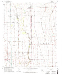 1963 Vanduser1964 Print · USGSIn the Missouri Bootheel during the early 1960s, the landscape around Vanduser was defined by its rail-line settlements and complex drainage works. Researchers can trace family roots at Carpenter Cem and explore the rail corridor through Crowder and Tanner.2 unique versions available
 - 1963 Map of Sikeston South, 1964 Print
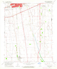 1963 Sikeston South1964 Print · USGSThe Missouri Bootheel was undergoing significant growth in the 1960s as Sikeston expanded across the high ground of Sikeston Ridge. Genealogists and researchers can trace local landmarks like Little Vine Ch, Matthews Sch, and the St Louis - San Francisco rail corridor.3 unique versions available
 - 1963 Map of Sikeston, 1968 Print
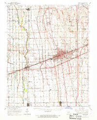 1963 Sikeston1968 Print · USGSSikeston and the surrounding Missouri lowlands are captured here in the mid-sixties, showcasing a landscape shaped by drainage engineering and railroads. Researchers can trace family sites at Silent Hill Cem, find the Pharris Ridge Sch, or locate the old Drive-in Theater.
End of results
Showing maps 1-4 of 4
Top cities near Sikeston
- Charleston historical maps
- East Prairie historical maps
- Oran historical maps
- Morehouse historical maps
- Morley historical maps
- Benton historical maps
See more
Frequently asked questions
- What are the different types of historical maps available for Sikeston?
- What is the oldest map of Sikeston?
- Where can I purchase historical maps of Sikeston for my home or office?
- Where can I download high-res historical maps of Sikeston?
- Are there historical topographic maps available for Sikeston?
- Is there historical aerial imagery available for Sikeston?
- Where are historical maps of Sikeston sourced from?