1980s Maps of Montier, Missouri
Explore 2 historic maps of Montier from the 1980s. These maps offer a rare glimpse into what life looked like during the 1980s — showing old roads, neighborhoods, homes, and landmarks that have changed or disappeared over time.
Whether you're researching your family's past, planning a metal detecting trip, or studying how Montier's landscape evolved across the 1980s, these high-resolution maps are a powerful tool for exploring the history of this region.
- Focus on a specific era: All maps on this page are from the 1980s, giving you a focused view of this time period.
- See what’s changed: Compare century-old streets, trails, and buildings to today's modern landscape using overlays and satellite layers.
- Research with precision: Use these maps for genealogy, historical research, land use analysis, or educational projects.
- View, download, or print: Maps are fully viewable online in high resolution, and can be downloaded or printed for your own records.
Start exploring Montier's history through authentic maps from the 1980s. This is your window into the past.
Montier, MO maps
(2)- 1984 Map of West Plains
 1984 West Plains1984 Print · USGSThe Missouri Ozarks are mapped here in the mid-1980s, centered on the regional hub of West Plains and the river corridors of the Eleven Point River. Trace the old rail lines and timber towns of Willow Springs, Mountain View, and Birch Tree through the Mark Twain National Forest.2 unique versions available
 - 1986 Map of Montier
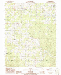 1986 Montier1986 Print · USGSShannon and Oregon Counties in the mid-1980s reveal a landscape of rural congregations and former rail lines. Researchers can trace the Old Railroad Grade past the Abd Mine and locate historic meeting places like Bethlehem Ch or Corinth Ch.
End of results
Showing maps 1-2 of 2
Top cities near Montier
- Mountain View historical maps
- Birch Tree historical maps
- Eminence historical maps
- Summersville historical maps
Frequently asked questions
- What are the different types of historical maps available for Montier?
- What is the oldest map of Montier?
- Where can I purchase historical maps of Montier for my home or office?
- Where can I download high-res historical maps of Montier?
- Are there historical topographic maps available for Montier?
- Is there historical aerial imagery available for Montier?
- Where are historical maps of Montier sourced from?