1910s Maps of West Eminence, Missouri
Explore 2 historic maps of West Eminence from the 1910s. These maps offer a rare glimpse into what life looked like during the 1910s — showing old roads, neighborhoods, homes, and landmarks that have changed or disappeared over time.
Whether you're researching your family's past, planning a metal detecting trip, or studying how West Eminence's landscape evolved across the 1910s, these high-resolution maps are a powerful tool for exploring the history of this region.
- Focus on a specific era: All maps on this page are from the 1910s, giving you a focused view of this time period.
- See what’s changed: Compare century-old streets, trails, and buildings to today's modern landscape using overlays and satellite layers.
- Research with precision: Use these maps for genealogy, historical research, land use analysis, or educational projects.
- View, download, or print: Maps are fully viewable online in high resolution, and can be downloaded or printed for your own records.
Start exploring West Eminence's history through authentic maps from the 1910s. This is your window into the past.
West Eminence, MO maps
(2)- 1915 Map of Eminence, 1956 Print
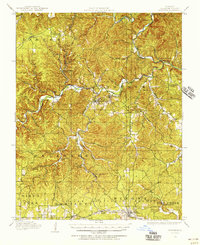 1915 Eminence1956 Print · USGSShannon County at the height of the early twentieth-century timber era shows a landscape defined by deep hollows and the winding Current River. Genealogists can trace family roots through numerous rural landmarks like Angeline P.O., West Eminence, and over a dozen country schools including Shawnee School.2 unique versions available
 - 1917 Map of Eminence
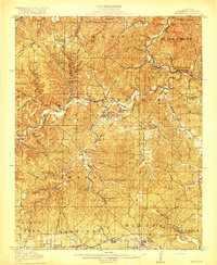 1917 Eminence1917 Print · USGSThe Ozark highlands of Shannon County are captured here just as the timber industry and river-based commerce shaped local life. Researchers can trace the footprints of lost rural communities at Horse Hollow Angeline P.O., Delaware, and West Eminence.4 unique versions available
End of results
Showing maps 1-2 of 2
Top cities near West Eminence
Frequently asked questions
- What are the different types of historical maps available for West Eminence?
- What is the oldest map of West Eminence?
- Where can I purchase historical maps of West Eminence for my home or office?
- Where can I download high-res historical maps of West Eminence?
- Are there historical topographic maps available for West Eminence?
- Is there historical aerial imagery available for West Eminence?
- Where are historical maps of West Eminence sourced from?